Weather Alert in Alaska
Winter Weather Advisory issued February 24 at 5:43PM AKST until February 26 at 6:00AM AKST by NWS Juneau AK
AREAS AFFECTED: City and Borough of Juneau
DESCRIPTION: ...PERIODS OF SNOW THROUGH MID WEEK... .Light snow continuing in various inland areas this evening. There should be a brief break in the snow tonight before more snow showers move in from the west Wednesday into Wednesday night. Snow accumulations will be highly variable Wednesday into Wednesday night with W to SW oriented slopes favored for higher snow totals. * WHAT...Snow. Additional snow accumulations of 4 to 10 inches. * WHERE...City and Borough of Juneau. * WHEN...Until 6 AM AKST Thursday. * IMPACTS...Travel could be very difficult and is discouraged. The hazardous conditions could impact the morning or evening commute. * ADDITIONAL DETAILS...Snow Tuesday afternoon and evening is expected to diminish Tuesday night, but will ramp back up Wednesday morning into Wednesday night. Snow accumulations will be highly variable with localized locations having a chance of seeing accumulations a few inches higher or lower then the above range.
INSTRUCTION: Slow down and use caution while traveling. People are urged to prepare their property before the onset of winter weather. For the latest road conditions, where available, call 5 1 1 or visit 511.alaska.gov.
Want more detail? Get the Complete 7 Day and Night Detailed Forecast!
Current U.S. National Radar--Current
The Current National Weather Radar is shown below with a UTC Time (subtract 5 hours from UTC to get Eastern Time).

National Weather Forecast--Current
The Current National Weather Forecast and National Weather Map are shown below.

National Weather Forecast for Tomorrow
Tomorrow National Weather Forecast and Tomorrow National Weather Map are show below.

North America Water Vapor (Moisture)
This map shows recent moisture content over North America. Bright and colored areas show high moisture (ie, clouds); brown indicates very little moisture present; black indicates no moisture.

Weather Topic: What are Cirrus Clouds?
Home - Education - Cloud Types - Cirrus Clouds
 Next Topic: Condensation
Cirrus clouds are high-level clouds that occur above 20,000 feet
and are composed mainly of ice crystals.
They are thin and wispy in appearance.
What do they indicate?
They are often the first sign of an approaching storm.
Next Topic: Condensation
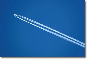
Weather Topic: What are Contrails?
Home - Education - Cloud Types - Contrails
 Next Topic: Cumulonimbus Clouds
A contrail is an artificial cloud, created by the passing of an
aircraft.
Contrails form because water vapor in the exhaust of aircraft engines is suspended
in the air under certain temperatures and humidity conditions. These contrails
are called exhaust contrails.
Another type of contrail can form due to a temporary reduction in air pressure
moving over the plane's surface, causing condensation.
These are called aerodynamic contrails.
When you can see your breath on a cold day, it is also because of condensation.
The reason contrails last longer than the condensation from your breath is
because the water in contrails freezes into ice particles.
Next Topic: Cumulonimbus Clouds
Current conditions powered by WeatherAPI.com


