Weather Alert in Michigan
Flood Warning issued April 3 at 8:54PM EDT until April 7 at 2:00PM EDT by NWS Gaylord MI
AREAS AFFECTED: Wexford, MI
DESCRIPTION: ...Forecast flooding changed from Minor to Moderate severity for the following rivers in Michigan... Manistee River near Sherman affecting Wexford County. For the Manistee River...including Sherman...Moderate flooding is forecast. * WHAT...Minor flooding is occurring and moderate flooding is forecast. This approaches the flood of record. * WHERE...Manistee River near Sherman. * WHEN...Until early Tuesday afternoon. * IMPACTS...At 16.0 feet, Flooding of property and homes adjacent to right bank of river along Ojibway Drive, Ottawa Drive, and Chippewa Drive 1 mile north of Sherman. Flooding of N11 Road between W14 Road and W16 Road 1 mile northwest of Mesick. * ADDITIONAL DETAILS... - At 8:30 PM EDT Friday the stage was 15.6 feet. - Bankfull stage is 14.0 feet. - Recent Activity...The maximum river stage in the 24 hours ending at 8:30 PM EDT Friday was 15.6 feet. - Forecast...The river is expected to rise to a crest of 16.1 feet tomorrow afternoon. It will then fall below flood stage Tuesday morning. - Flood stage is 15.0 feet. - Flood History...This crest compares to a previous crest of 16.0 feet on 03/18/1990. - http://www.weather.gov/safety/flood
INSTRUCTION: Motorists should not attempt to drive around barricades or drive cars through flooded areas. Additional information is available at www.weather.gov. The next statement will be issued Saturday afternoon at noon EDT.
Want more detail? Get the Complete 7 Day and Night Detailed Forecast!
Current U.S. National Radar--Current
The Current National Weather Radar is shown below with a UTC Time (subtract 5 hours from UTC to get Eastern Time).

National Weather Forecast--Current
The Current National Weather Forecast and National Weather Map are shown below.

National Weather Forecast for Tomorrow
Tomorrow National Weather Forecast and Tomorrow National Weather Map are show below.

North America Water Vapor (Moisture)
This map shows recent moisture content over North America. Bright and colored areas show high moisture (ie, clouds); brown indicates very little moisture present; black indicates no moisture.

Weather Topic: What is Hail?
Home - Education - Precipitation - Hail
 Next Topic: Hole Punch Clouds
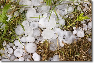
Hail is a form of precipitation which is recognized by large solid balls or
clumps of ice. Hail is created by thunderstorm clouds with strong updrafts of wind.
As the hailstones remain in the updraft, ice is deposited onto them until their
weight becomes heavy enough for them to fall to the earth's surface.
Hail storms can cause significant damage to crops, aircrafts, and man-made structures,
despite the fact that the duration is usually less than ten minutes.
Next Topic: Hole Punch Clouds
Weather Topic: What are Mammatus Clouds?
Home - Education - Cloud Types - Mammatus Clouds
 Next Topic: Nimbostratus Clouds
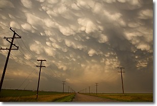
A mammatus cloud is a cloud with a unique feature which resembles
a web of pouches hanging along the base of the cloud.
In the United States, mammatus clouds tend to form in the warmer months, commonly
in the Midwest and eastern regions.
While they usually form at the bottom of a cumulonimbis cloud, they can also form
under altostratus, altocumulus, stratocumulus, and cirrus clouds. Mammatus clouds
warn that severe weather is close.
Next Topic: Nimbostratus Clouds
Current conditions powered by WeatherAPI.com


