Weather Alert in Hawaii
High Surf Advisory issued February 24 at 3:21AM HST until February 24 at 6:00PM HST by NWS Honolulu HI
AREAS AFFECTED: Maui Leeward West; Kohala; Molokai West; Lanai Windward
DESCRIPTION: ...HIGH SURF WARNING FOR NORTH AND EAST FACING SHORES OF NIIHAU KAUAI OAHU MOLOKAI MAUI AND BIG ISLAND THROUGH THIS AFTERNOON... ...HIGH SURF ADVISORY FOR WEST FACING SHORES OF MOLOKAI MAUI AND BIG ISLAND AND FOR NORTH FACING SHORES OF LANAI THROUGH THIS AFTERNOON... .A long period north-northeast (010-030 degrees) has peaked overnight and will hold through the morning hours, producing much larger than normal surf across some coastlines, especially in windward areas. The swell will gradually decline late this afternoon through Friday. * WHAT...Along west facing shores of the Big Island in the Kohala Districts, surf peaking at 7 to 10 feet before declining late this afternoon. Along west facing shores of Maui, surf peaking at 12 to 16 feet. Along west facing shores of Molokai and north facing shores of Lanai, surf peaking at 12 to 16 feet this morning before slowly declining late this afternoon. * WHERE...West facing shores of Molokai, Maui, and Big Island and for north facing shores of Lanai. * WHEN...Until 6 PM HST this evening. * IMPACTS...Moderate. Strong breaking waves and strong currents will make swimming dangerous.
INSTRUCTION: Heed all advice from ocean safety officials. When in doubt, don't go out.
Want more detail? Get the Complete 7 Day and Night Detailed Forecast!
Current U.S. National Radar--Current
The Current National Weather Radar is shown below with a UTC Time (subtract 5 hours from UTC to get Eastern Time).

National Weather Forecast--Current
The Current National Weather Forecast and National Weather Map are shown below.

National Weather Forecast for Tomorrow
Tomorrow National Weather Forecast and Tomorrow National Weather Map are show below.

North America Water Vapor (Moisture)
This map shows recent moisture content over North America. Bright and colored areas show high moisture (ie, clouds); brown indicates very little moisture present; black indicates no moisture.

Weather Topic: What are Hole Punch Clouds?
Home - Education - Cloud Types - Hole Punch Clouds
 Next Topic: Mammatus Clouds
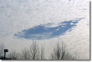
A hole punch cloud is an unusual occurrence when a disk-shaped
hole appears in a cirrostratus, cirrocumulus, or altocumulus cloud.
When part of the cloud forms ice crystals, water droplets in the surrounding area
of the cloud evaporate. The effect of this process produces a large elliptical
gap in the cloud. The hole punch cloud formation is rare, but it is not specific
to any geographic area.
Other names which have been used to describe this phenomena include fallstreak hole,
skypunch, and cloud hole.
Next Topic: Mammatus Clouds
Weather Topic: What are Nimbostratus Clouds?
Home - Education - Cloud Types - Nimbostratus Clouds
 Next Topic: Precipitation
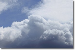
A nimbostratus cloud is similar to a stratus cloud in its formless,
smooth appearance. However, a nimbostratus cloud is darker than a stratus cloud,
because it is thicker.
Unlike a stratus cloud, a nimbostratus cloud typically brings with it the threat
of moderate to heavy precipitation. In some cases, the precipitation may evaporate
before reaching the ground, a phenomenon known as virga.
Next Topic: Precipitation
Current conditions powered by WeatherAPI.com


