Weather Alert in Alabama
Flood Advisory issued February 27 at 12:23AM CST until February 27 at 4:15AM CST by NWS Birmingham AL
AREAS AFFECTED: Bibb, AL; Jefferson, AL; St. Clair, AL; Shelby, AL; Talladega, AL; Tuscaloosa, AL
DESCRIPTION: * WHAT...Urban and small stream flooding caused by excessive rainfall is expected. * WHERE...A portion of central Alabama, including the following counties, Bibb, Jefferson, Shelby, St. Clair, Talladega and Tuscaloosa. * WHEN...Until 415 AM CST. * IMPACTS...Minor flooding in low-lying and poor drainage areas. Some low-water crossings may become impassable. River or stream flows are elevated. * ADDITIONAL DETAILS... - At 1223 AM CST, Doppler radar indicated heavy rain due to thunderstorms. This will cause urban and small stream flooding. - Some locations that will experience flooding include... Southwestern Birmingham, Tuscaloosa, Hoover, Vestavia Hills, Alabaster, Bessemer, Homewood, Northport, Pelham, Oxford, Helena, Hueytown, Talladega, Sylacauga, Pell City, Calera, Chelsea, Montevallo, Childersburg and Columbiana.
INSTRUCTION: Turn around, don't drown when encountering flooded roads. Most flood deaths occur in vehicles. Be especially cautious at night when it is harder to recognize the dangers of flooding. Please report observed flooding to local emergency services or law enforcement and request they pass this information to the National Weather Service when you can do so safely.
Want more detail? Get the Complete 7 Day and Night Detailed Forecast!
Current U.S. National Radar--Current
The Current National Weather Radar is shown below with a UTC Time (subtract 5 hours from UTC to get Eastern Time).

National Weather Forecast--Current
The Current National Weather Forecast and National Weather Map are shown below.

National Weather Forecast for Tomorrow
Tomorrow National Weather Forecast and Tomorrow National Weather Map are show below.

North America Water Vapor (Moisture)
This map shows recent moisture content over North America. Bright and colored areas show high moisture (ie, clouds); brown indicates very little moisture present; black indicates no moisture.

Weather Topic: What is Graupel?
Home - Education - Precipitation - Graupel
 Next Topic: Hail
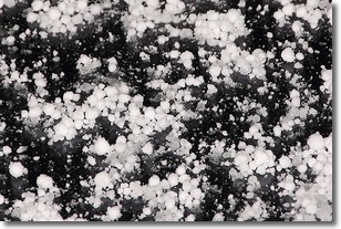
Graupel is a form of precipitation that is created by atmospheric conditions
which cause supercooled water droplets to contact snow crystals and freeze to
their surface.
Sometimes known as soft hail or snow pellets, graupel is delicate and easily
destroyed by touch. Whereas hail usually falls during severe weather, graupel
doesn't require such conditions to form, and can form in mild precipitation
similar to situations which produce snowfall.
Next Topic: Hail
Weather Topic: What are Hole Punch Clouds?
Home - Education - Cloud Types - Hole Punch Clouds
 Next Topic: Mammatus Clouds
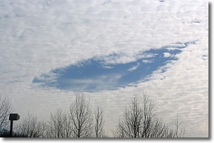
A hole punch cloud is an unusual occurrence when a disk-shaped
hole appears in a cirrostratus, cirrocumulus, or altocumulus cloud.
When part of the cloud forms ice crystals, water droplets in the surrounding area
of the cloud evaporate. The effect of this process produces a large elliptical
gap in the cloud. The hole punch cloud formation is rare, but it is not specific
to any geographic area.
Other names which have been used to describe this phenomena include fallstreak hole,
skypunch, and cloud hole.
Next Topic: Mammatus Clouds
Current conditions powered by WeatherAPI.com


