Weather Alert in Hawaii
Coastal Flood Statement issued September 5 at 3:02PM HST until September 7 at 6:00PM HST by NWS Honolulu HI
AREAS AFFECTED: Niihau; Kauai Southwest; Waianae Coast; Oahu North Shore; Olomana; Kahoolawe; Maui Windward West; Maui Leeward West; Kona; Kohala; Kauai North; Kauai East; Kauai South; East Honolulu; Honolulu Metro; Ewa Plain; Koolau Windward; Molokai Windward; Molokai Southeast; Molokai North; Molokai West; Molokai Leeward South; Lanai Windward; Lanai Leeward; Lanai South; Maui Central Valley North; Maui Central Valley South; Windward Haleakala; Kipahulu; South Maui/Upcountry; South Haleakala; Big Island South; Big Island Southeast; Big Island East; Big Island North
DESCRIPTION: ...MINOR COASTAL FLOODING DURING THE HIGH TIDE THROUGH SUNDAY AFTERNOON FOR LOW LYING COASTAL AREAS OF ALL ISLANDS... Peak high tides associated with the lunar cycle will lead to minor coastal flooding along shorelines and low lying coastal areas during the daily afternoon high tide through Sunday. * WHAT...Isolated minor coastal flooding. * WHERE...Portions of Kahoolawe, Kauai, Lanai, Maui, Molokai, Niihau, Oahu and the Big Island. * WHEN...Through Sunday afternoon. * IMPACTS...Flooding of beaches that are normally dry, minor coastal erosion, and saltwater inundation.
INSTRUCTION: Avoid driving through flooded roadways. If you are forced to drive through salt water, be sure to rinse your vehicle with fresh water. Move electronics, vehicles or other valuables to higher ground. Monitor vessels to ensure mooring lines don't get too tight and watch out for overwash around boat ramps. Secure canoes or other watercraft stowed on beaches.
Want more detail? Get the Complete 7 Day and Night Detailed Forecast!
Current U.S. National Radar--Current
The Current National Weather Radar is shown below with a UTC Time (subtract 5 hours from UTC to get Eastern Time).

National Weather Forecast--Current
The Current National Weather Forecast and National Weather Map are shown below.

National Weather Forecast for Tomorrow
Tomorrow National Weather Forecast and Tomorrow National Weather Map are show below.

North America Water Vapor (Moisture)
This map shows recent moisture content over North America. Bright and colored areas show high moisture (ie, clouds); brown indicates very little moisture present; black indicates no moisture.

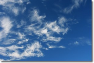
Weather Topic: What are Cirrostratus Clouds?
Home - Education - Cloud Types - Cirrostratus Clouds
 Next Topic: Cirrus Clouds
Cirrostratus clouds are high, thin clouds that form above
20,000 feet and are made mostly of ice crystals. They sometimes look like giant
feathers, horse tails, or curls of hair in the sky.
These clouds are pushed by the jet stream and can move at high speeds reaching
100 mph.
What do they indicate?
They indicate that a precipitation is likely within 24 hours.
Next Topic: Cirrus Clouds
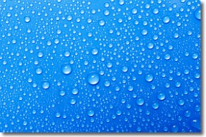
Weather Topic: What is Condensation?
Home - Education - Precipitation - Condensation
 Next Topic: Contrails
Condensation is the process which creates clouds, and therefore
it is a crucial process in the water cycle.
Condensation is the change of matter from a state of gas into a state of liquid,
and it happens because water molecules release heat into the atmosphere and
become organized into a more closely packed structure, what we might see as
water droplets.
Water is always present in the air around us as a vapor, but it's too small for
us to see. When water undergoes the process of condensation it becomes organized
into visible water droplets. You've probably seen condensation happen before on the
surface of a cold drink!
Next Topic: Contrails
Current conditions powered by WeatherAPI.com


