Weather Alert in Maine
High Surf Advisory issued August 21 at 1:59PM EDT until August 23 at 2:00PM EDT by NWS Caribou ME
AREAS AFFECTED: Coastal Hancock; Coastal Washington
DESCRIPTION: * WHAT....Waves building to 7 to 10 feet, with a wave period of 13 to 17 seconds. Minor splashover is possible at high tide Friday night. * WHERE...Coastal Hancock and Coastal Washington Counties. * WHEN...For the High Surf Advisory, from 6 PM this evening to 2 PM EDT Saturday. For the Coastal Flood Statement, Friday evening at high tide. SHORELINE FLOOD IMPACTS...Building waves will cause minor splash-over on exposed coastal roads and shorelines. Pedestrians and motorists should use caution along shorelines.Large waves can present a danger to people on rocks above the water. Stay away from rock outcrops along the shoreline exposed to ocean waves...as waves can easily sweep people into the cold ocean water. * IMPACTS...Rip currents and sneaker waves will lead to dangerous beach conditions. Some minor beach erosion is possible. Minor splashover possible during high tide Friday Evening. Large waves can present a danger to people on rocks above the water. Stay away from rock outcrops along the shoreline exposed to ocean waves...as waves can easily sweep people into the cold ocean water.
INSTRUCTION: A High Surf Advisory Means That High Surf Will Affect Beaches In The Advisory area...producing rip currents and localized beach erosion.
Want more detail? Get the Complete 7 Day and Night Detailed Forecast!
Current U.S. National Radar--Current
The Current National Weather Radar is shown below with a UTC Time (subtract 5 hours from UTC to get Eastern Time).

National Weather Forecast--Current
The Current National Weather Forecast and National Weather Map are shown below.

National Weather Forecast for Tomorrow
Tomorrow National Weather Forecast and Tomorrow National Weather Map are show below.

North America Water Vapor (Moisture)
This map shows recent moisture content over North America. Bright and colored areas show high moisture (ie, clouds); brown indicates very little moisture present; black indicates no moisture.

Weather Topic: What is Graupel?
Home - Education - Precipitation - Graupel
 Next Topic: Hail
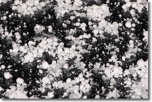
Graupel is a form of precipitation that is created by atmospheric conditions
which cause supercooled water droplets to contact snow crystals and freeze to
their surface.
Sometimes known as soft hail or snow pellets, graupel is delicate and easily
destroyed by touch. Whereas hail usually falls during severe weather, graupel
doesn't require such conditions to form, and can form in mild precipitation
similar to situations which produce snowfall.
Next Topic: Hail
Weather Topic: What are Hole Punch Clouds?
Home - Education - Cloud Types - Hole Punch Clouds
 Next Topic: Mammatus Clouds
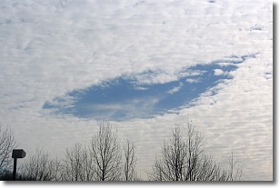
A hole punch cloud is an unusual occurrence when a disk-shaped
hole appears in a cirrostratus, cirrocumulus, or altocumulus cloud.
When part of the cloud forms ice crystals, water droplets in the surrounding area
of the cloud evaporate. The effect of this process produces a large elliptical
gap in the cloud. The hole punch cloud formation is rare, but it is not specific
to any geographic area.
Other names which have been used to describe this phenomena include fallstreak hole,
skypunch, and cloud hole.
Next Topic: Mammatus Clouds
Current conditions powered by WeatherAPI.com


