Weather Alert in California
Air Quality Alert issued June 27 at 3:17PM MST by NWS Phoenix AZ
AREAS AFFECTED: Imperial County West; Imperial Valley
DESCRIPTION: * WHAT...The Imperial County APCD has issued an air quality alert due to increased fine particle pollution from wildfire smoke. * WHERE...Western portion of Imperial County including the Imperial Valley. Levels of particle pollution can vary by time and location depending on fire activity and local weather conditions. * WHEN...The impact of international transport smoke is expected through the weekend. * IMPACTS...Particles in wildfire smoke can get deep into the lungs and cause serious health problems such as heart attacks, strokes, asthma attacks, and difficulty breathing. Everyone can be affected, but people with lung or heart disease, older adults, people who are pregnant, children, and those who spend a lot of time outdoors are at greater risk.
INSTRUCTION: To protect your health, if you smell or see smoke: * Remain indoors with windows and doors closed * Avoid intense outdoor physical activity * Run your air conditioner and/or an air purifier * If you must be outdoors, keep the time brief and wear a well- fitting N-95 mask * Do not use whole house fans or swamp coolers that bring in outside air if you have other methods to stay cool * Avoid other sources of pollution such as fireplaces, candles, incense, grilling, and gasoline-powered lawn and garden equipment * ADDITIONAL DETAILS... To view current and forecast air quality within Imperial County visit the Imperial County Air Quality website at http://www.imperialvalleyair.org/ or follow ICAPCD on Twitter, facebook or Instagram (@county_air).
Want more detail? Get the Complete 7 Day and Night Detailed Forecast!
Current U.S. National Radar--Current
The Current National Weather Radar is shown below with a UTC Time (subtract 5 hours from UTC to get Eastern Time).

National Weather Forecast--Current
The Current National Weather Forecast and National Weather Map are shown below.

National Weather Forecast for Tomorrow
Tomorrow National Weather Forecast and Tomorrow National Weather Map are show below.

North America Water Vapor (Moisture)
This map shows recent moisture content over North America. Bright and colored areas show high moisture (ie, clouds); brown indicates very little moisture present; black indicates no moisture.

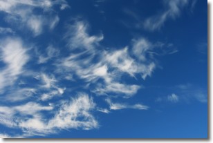
Weather Topic: What are Cirrostratus Clouds?
Home - Education - Cloud Types - Cirrostratus Clouds
 Next Topic: Cirrus Clouds
Cirrostratus clouds are high, thin clouds that form above
20,000 feet and are made mostly of ice crystals. They sometimes look like giant
feathers, horse tails, or curls of hair in the sky.
These clouds are pushed by the jet stream and can move at high speeds reaching
100 mph.
What do they indicate?
They indicate that a precipitation is likely within 24 hours.
Next Topic: Cirrus Clouds
Weather Topic: What is Condensation?
Home - Education - Precipitation - Condensation
 Next Topic: Contrails
Condensation is the process which creates clouds, and therefore
it is a crucial process in the water cycle.
Condensation is the change of matter from a state of gas into a state of liquid,
and it happens because water molecules release heat into the atmosphere and
become organized into a more closely packed structure, what we might see as
water droplets.
Water is always present in the air around us as a vapor, but it's too small for
us to see. When water undergoes the process of condensation it becomes organized
into visible water droplets. You've probably seen condensation happen before on the
surface of a cold drink!
Next Topic: Contrails
Current conditions powered by WeatherAPI.com


