Weather Alert in Nebraska
Flood Watch issued February 5 at 3:23AM CST until February 9 at 10:00PM CST by NWS Omaha/Valley NE
AREAS AFFECTED: Antelope; Pierce; Madison; Stanton; Cuming; Platte; Colfax; Dodge; Washington; Butler; Saunders; Douglas; Sarpy; Cass
DESCRIPTION: A watch has been issued for the Platte, Elkhorn, and Loup rivers due to potential ice jam development. This heightened threat is due to persistent warm weather. Those with interests along area rivers, especially in low-lying areas, should remain vigilant to the potential for rapidly rising water. * WHAT...Flooding caused by an ice jam is possible. * WHERE...Portions of east central, northeast, and southeast Nebraska, including the following counties, in east central Nebraska, Butler, Dodge, Douglas, Sarpy, Saunders and Washington. In northeast Nebraska, Antelope, Colfax, Cuming, Madison, Pierce, Platte and Stanton. In southeast Nebraska, Cass. * WHEN...Through Monday evening. * IMPACTS...The formation of an ice jam could result in sudden rises of water, leading to a rapid flooding situation. Ice jams can cause water level fluctuations of 1 to 3 feet over a very short time period and without much notice. * ADDITIONAL DETAILS... - While no ice movement has been observed or reported, several consecutive days of highs ranging from the upper 40s to mid 60s suggest breakup and movement is imminent.
INSTRUCTION: You should monitor later forecasts and be alert for possible Flood Warnings. Those living in areas prone to flooding should be prepared to take action should flooding develop.
Want more detail? Get the Complete 7 Day and Night Detailed Forecast!
Current U.S. National Radar--Current
The Current National Weather Radar is shown below with a UTC Time (subtract 5 hours from UTC to get Eastern Time).

National Weather Forecast--Current
The Current National Weather Forecast and National Weather Map are shown below.

National Weather Forecast for Tomorrow
Tomorrow National Weather Forecast and Tomorrow National Weather Map are show below.

North America Water Vapor (Moisture)
This map shows recent moisture content over North America. Bright and colored areas show high moisture (ie, clouds); brown indicates very little moisture present; black indicates no moisture.

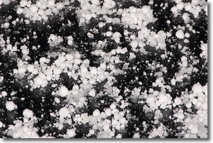
Weather Topic: What is Graupel?
Home - Education - Precipitation - Graupel
 Next Topic: Hail
Graupel is a form of precipitation that is created by atmospheric conditions
which cause supercooled water droplets to contact snow crystals and freeze to
their surface.
Sometimes known as soft hail or snow pellets, graupel is delicate and easily
destroyed by touch. Whereas hail usually falls during severe weather, graupel
doesn't require such conditions to form, and can form in mild precipitation
similar to situations which produce snowfall.
Next Topic: Hail
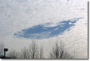
Weather Topic: What are Hole Punch Clouds?
Home - Education - Cloud Types - Hole Punch Clouds
 Next Topic: Mammatus Clouds
A hole punch cloud is an unusual occurrence when a disk-shaped
hole appears in a cirrostratus, cirrocumulus, or altocumulus cloud.
When part of the cloud forms ice crystals, water droplets in the surrounding area
of the cloud evaporate. The effect of this process produces a large elliptical
gap in the cloud. The hole punch cloud formation is rare, but it is not specific
to any geographic area.
Other names which have been used to describe this phenomena include fallstreak hole,
skypunch, and cloud hole.
Next Topic: Mammatus Clouds
Current conditions powered by WeatherAPI.com


