Weather Alert in North Carolina
Special Weather Statement issued February 5 at 7:05PM EST by NWS Wilmington NC
AREAS AFFECTED: Robeson; Bladen; Columbus; Inland Pender; Coastal Pender; Inland New Hanover; Coastal New Hanover; Inland Brunswick; Coastal Brunswick; Marlboro; Darlington; Dillon; Florence; Marion; Williamsburg; Coastal Horry; Inland Georgetown; Coastal Georgetown; Central Horry; Northern Horry
DESCRIPTION: Standing water from the recent rainfall and any leftover melting snow will result in patchy black ice along or across area roadways and thoroughfares as temperatures drop to and below 32 later this evening, and into the 20s overnight. Icy spots could form on paved surfaces such as bridges and overpasses, primary and especially less traveled secondary roads, parking lots, sidewalks and driveways. Black ice is difficult to see and distinguish from dry surfaces. The deceptive nature of black ice can catch you unaware while you are driving or walking, causing you to lose control of your motor vehicle or for one to slip and fall.
INSTRUCTION: If you plan to drive or walk, remain alert for those slick spots. Slow your driving speed and use care when walking on sidewalks, driveways or across parking lots. Slips and falls constitute a leading cause of injuries during the winter weather season.
Want more detail? Get the Complete 7 Day and Night Detailed Forecast!
Current U.S. National Radar--Current
The Current National Weather Radar is shown below with a UTC Time (subtract 5 hours from UTC to get Eastern Time).

National Weather Forecast--Current
The Current National Weather Forecast and National Weather Map are shown below.

National Weather Forecast for Tomorrow
Tomorrow National Weather Forecast and Tomorrow National Weather Map are show below.

North America Water Vapor (Moisture)
This map shows recent moisture content over North America. Bright and colored areas show high moisture (ie, clouds); brown indicates very little moisture present; black indicates no moisture.

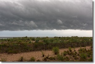
Weather Topic: What are Shelf Clouds?
Home - Education - Cloud Types - Shelf Clouds
 Next Topic: Sleet
A shelf cloud is similar to a wall cloud, but forms at the front
of a storm cloud, instead of at the rear, where wall clouds form.
A shelf cloud is caused by a series of events set into motion by the advancing
storm; first, cool air settles along the ground where precipitation has just fallen.
As the cool air is brought in, the warmer air is displaced, and rises above it,
because it is less dense. When the warmer air reaches the bottom of the storm cloud,
it begins to cool again, and the resulting condensation is a visible shelf cloud.
Next Topic: Sleet
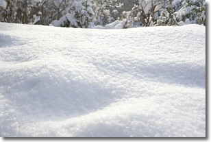
Weather Topic: What is Snow?
Home - Education - Precipitation - Snow
 Next Topic: Stratocumulus Clouds
Snow is precipitation taking the form of ice crystals. Each ice crystal, or snowflake,
has unique characteristics, but all of them grow in a hexagonal structure.
Snowfall can last for sustained periods of time and result in significant buildup
of snow on the ground.
On the earth's surface, snow starts out light and powdery, but as it begins to melt
it tends to become more granular, producing small bits of ice which have the consistency of
sand. After several cycles of melting and freezing, snow can become very dense
and ice-like, commonly known as snow pack.
Next Topic: Stratocumulus Clouds
Current conditions powered by WeatherAPI.com


