Weather Alert in District of Columbia
Extreme Cold Watch issued February 5 at 1:07PM EST until February 8 at 10:00AM EST by NWS Baltimore MD/Washington DC
AREAS AFFECTED: District of Columbia; Washington; Frederick; Carroll; Northern Baltimore; Cecil; Southern Baltimore; Prince Georges; Anne Arundel; Northwest Montgomery; Central and Southeast Montgomery; Northwest Howard; Central and Southeast Howard; Northwest Harford; Southeast Harford; Augusta; Rockingham; Shenandoah; Frederick; Page; Warren; Clarke; Rappahannock; Fairfax; Arlington/Falls Church/Alexandria; Northern Fauquier; Western Loudoun; Eastern Loudoun; Northwest Prince William; Central and Southeast Prince William/Manassas/Manassas Park; Hampshire; Morgan; Berkeley; Jefferson; Hardy
DESCRIPTION: * WHAT...Dangerously cold wind chills as low as 0 to 10 degrees below zero possible east of the Blue Ridge, and as low as 15 degrees below zero west of the Blue Ridge. * WHERE...Portions of DC, central, north central, northeast, and northern Maryland, northern, northwest, and western Virginia, and eastern and panhandle West Virginia. * WHEN...From late Friday night through Sunday morning. * IMPACTS...The cold wind chills as low as 15 below zero could result in hypothermia if precautions are not taken. Frostbite and hypothermia will occur if unprotected skin is exposed to these temperatures. * ADDITIONAL DETAILS...Wind chills will remain at or below zero during the day on Saturday due to windy conditions and cold temperatures.
INSTRUCTION: Dress in layers including a hat, face mask, and gloves if you must go outside. Keep pets indoors as much as possible. Make sure outdoor animals have a warm, dry shelter, food, and unfrozen water. Make frequent checks on older family, friends, and neighbors. Ensure portable heaters are used correctly. Do not use generators or grills inside.
Want more detail? Get the Complete 7 Day and Night Detailed Forecast!
Current U.S. National Radar--Current
The Current National Weather Radar is shown below with a UTC Time (subtract 5 hours from UTC to get Eastern Time).

National Weather Forecast--Current
The Current National Weather Forecast and National Weather Map are shown below.

National Weather Forecast for Tomorrow
Tomorrow National Weather Forecast and Tomorrow National Weather Map are show below.

North America Water Vapor (Moisture)
This map shows recent moisture content over North America. Bright and colored areas show high moisture (ie, clouds); brown indicates very little moisture present; black indicates no moisture.

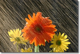
Weather Topic: What is Precipitation?
Home - Education - Precipitation - Precipitation
 Next Topic: Rain
Precipitation can refer to many different forms of water that
may fall from clouds. Precipitation occurs after a cloud has become saturated to
the point where its water particles are more dense than the air below the cloud.
In most cases, precipitation will reach the ground, but it is not uncommon for
precipitation to evaporate before it reaches the earth's surface.
When precipitation evaporates before it contacts the ground it is called Virga.
Graupel, hail, sleet, rain, drizzle, and snow are forms of precipitation, but fog
and mist are not considered precipitation because the water vapor which
constitutes them isn't dense enough to fall to the ground.
Next Topic: Rain
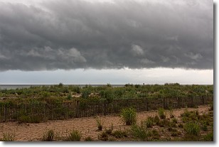
Weather Topic: What are Shelf Clouds?
Home - Education - Cloud Types - Shelf Clouds
 Next Topic: Sleet
A shelf cloud is similar to a wall cloud, but forms at the front
of a storm cloud, instead of at the rear, where wall clouds form.
A shelf cloud is caused by a series of events set into motion by the advancing
storm; first, cool air settles along the ground where precipitation has just fallen.
As the cool air is brought in, the warmer air is displaced, and rises above it,
because it is less dense. When the warmer air reaches the bottom of the storm cloud,
it begins to cool again, and the resulting condensation is a visible shelf cloud.
Next Topic: Sleet
Current conditions powered by WeatherAPI.com


