Weather Alert in Texas
Flood Warning issued April 29 at 8:41AM CDT until May 4 at 7:43AM CDT by NWS Norman OK
AREAS AFFECTED: Clay, TX; Wichita, TX
DESCRIPTION: ...The National Weather Service in Norman OK has issued a Flood Warning for the following rivers in Texas... Wichita River at Wichita Falls affecting Clay and Wichita Counties. * WHAT...Major flooding is forecast. * WHERE...Wichita River at Wichita Falls. * WHEN...From Wednesday morning to Sunday morning. * IMPACTS...At 22.0 feet, In Wichita Falls... extensive flooding occurs in Harrell and Lucy Parks. Flooding occurs in homes north of Third Street and in Tanglewood Hollow... and in Scotland Park. Flood depths up to 2 feet occur in an area north of Sixth Street and east of Scott Avenue. Agricultural areas upstream and downstream from Wichita Falls experience widespread flood depths up to 4 feet. * ADDITIONAL DETAILS... - At 7:45 AM CDT Tuesday the stage was 10.4 feet. - Bankfull stage is 18.0 feet. - Forecast...The river will fall to 9.8 feet this afternoon. The river is expected to rise above flood stage tomorrow morning to 22.5 feet tomorrow evening. - Flood stage is 18.0 feet. - Flood History...This crest compares to a previous crest of 22.7 feet on 06/04/1941. - http://www.weather.gov/safety/flood
INSTRUCTION: Stay tuned to further developments by listening to your local radio, television, or NOAA Weather Radio for further information. Turn around, don't drown when encountering flooded roads. Most flood deaths occur in vehicles. Additional information is available at www.weather.gov.
Want more detail? Get the Complete 7 Day and Night Detailed Forecast!
Current U.S. National Radar--Current
The Current National Weather Radar is shown below with a UTC Time (subtract 5 hours from UTC to get Eastern Time).

National Weather Forecast--Current
The Current National Weather Forecast and National Weather Map are shown below.

National Weather Forecast for Tomorrow
Tomorrow National Weather Forecast and Tomorrow National Weather Map are show below.

North America Water Vapor (Moisture)
This map shows recent moisture content over North America. Bright and colored areas show high moisture (ie, clouds); brown indicates very little moisture present; black indicates no moisture.

Weather Topic: What is Graupel?
Home - Education - Precipitation - Graupel
 Next Topic: Hail
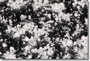
Graupel is a form of precipitation that is created by atmospheric conditions
which cause supercooled water droplets to contact snow crystals and freeze to
their surface.
Sometimes known as soft hail or snow pellets, graupel is delicate and easily
destroyed by touch. Whereas hail usually falls during severe weather, graupel
doesn't require such conditions to form, and can form in mild precipitation
similar to situations which produce snowfall.
Next Topic: Hail
Weather Topic: What are Hole Punch Clouds?
Home - Education - Cloud Types - Hole Punch Clouds
 Next Topic: Mammatus Clouds
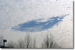
A hole punch cloud is an unusual occurrence when a disk-shaped
hole appears in a cirrostratus, cirrocumulus, or altocumulus cloud.
When part of the cloud forms ice crystals, water droplets in the surrounding area
of the cloud evaporate. The effect of this process produces a large elliptical
gap in the cloud. The hole punch cloud formation is rare, but it is not specific
to any geographic area.
Other names which have been used to describe this phenomena include fallstreak hole,
skypunch, and cloud hole.
Next Topic: Mammatus Clouds
Current conditions powered by WeatherAPI.com


