Weather Alert in Pennsylvania
Winter Weather Advisory issued February 5 at 12:41PM EST until February 7 at 7:00AM EST by NWS State College PA
AREAS AFFECTED: Cambria; Somerset
DESCRIPTION: * WHAT...Snow expected. Total snow accumulations between 2 and 4 inches. Localized amounts up to 8 inches in the highest elevations. Winds gusting as high as 45 to 50 mph. * WHERE...Cambria and Somerset Counties. * WHEN...From 10 AM Friday to 7 AM EST Saturday. The heaviest snow is expected Friday afternoon through Friday night. * IMPACTS...Plan on slippery road conditions. The hazardous travel conditions could impact the Friday evening commute. Gusty winds could bring down tree branches and cause significant blowing and drifting snow. * ADDITIONAL DETAILS...Near-blizzard conditions with very low visibility are possible at times late Friday night into early Saturday morning and could make travel extremely difficult. The heaviest snowfall is expected along and to the west of Route 219.
INSTRUCTION: Persons should delay travel if possible. If travel is absolutely necessary, drive with extreme caution and be prepared for sudden changes in visibility. Make sure your vehicle is winterized and in good working order.
Want more detail? Get the Complete 7 Day and Night Detailed Forecast!
Current U.S. National Radar--Current
The Current National Weather Radar is shown below with a UTC Time (subtract 5 hours from UTC to get Eastern Time).

National Weather Forecast--Current
The Current National Weather Forecast and National Weather Map are shown below.

National Weather Forecast for Tomorrow
Tomorrow National Weather Forecast and Tomorrow National Weather Map are show below.

North America Water Vapor (Moisture)
This map shows recent moisture content over North America. Bright and colored areas show high moisture (ie, clouds); brown indicates very little moisture present; black indicates no moisture.

Weather Topic: What is Freezing Rain?
Home - Education - Precipitation - Freezing Rain
 Next Topic: Graupel
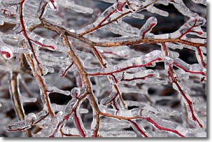
Freezing rain is a condition where precipitation which has fallen in the form of
water droplets reaches temperatures which are below freezing and freezes upon
coming into contact
with surface objects. The result of this precipitation is a glaze of ice which
can be damaging to plants and man-made structures. A severe onset of freezing
rain which results in a very thick glaze of ice is known as an ice storm.
Next Topic: Graupel
Weather Topic: What is Hail?
Home - Education - Precipitation - Hail
 Next Topic: Hole Punch Clouds
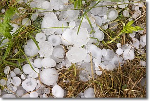
Hail is a form of precipitation which is recognized by large solid balls or
clumps of ice. Hail is created by thunderstorm clouds with strong updrafts of wind.
As the hailstones remain in the updraft, ice is deposited onto them until their
weight becomes heavy enough for them to fall to the earth's surface.
Hail storms can cause significant damage to crops, aircrafts, and man-made structures,
despite the fact that the duration is usually less than ten minutes.
Next Topic: Hole Punch Clouds
Current conditions powered by WeatherAPI.com


