Weather Alert in New York
Special Weather Statement issued September 4 at 4:31AM EDT by NWS Albany NY
AREAS AFFECTED: Northern Saratoga; Northern Warren; Northern Washington; Western Schenectady; Eastern Schenectady; Southern Saratoga; Western Albany; Eastern Albany; Western Rensselaer; Eastern Rensselaer; Eastern Greene; Western Columbia; Eastern Columbia; Eastern Ulster; Western Dutchess; Eastern Dutchess; Southeast Warren; Southern Washington
DESCRIPTION: The combination of dry fuels, southerly winds gusting between 25 and 35 mph, and relative humidity values between 35 and 40 percent will contribute to an elevated risk for fire spread today. The risk of fire spread will be highest in the Upper Hudson Valley/Champlain and Hudson Valley Fire Danger Rating Areas. This includes Warren, Saratoga, Washington, Schenectady, Albany, Rensselaer, Columbia, Dutchess, eastern Greene and eastern Ulster Counties. Any fires that develop in these areas could spread rapidly and become difficult to contain. Residents are encouraged to exercise caution if handling any potential ignition sources, such as machinery, cigarettes, or matches. This product was issued in coordination the the New York State Department of Environmental Conservation. For more information about wildfire danger and wildfire prevention, please visit their website at http://dec.ny.gov/environmental-protection/wildfires.
INSTRUCTION: N/A
Want more detail? Get the Complete 7 Day and Night Detailed Forecast!
Current U.S. National Radar--Current
The Current National Weather Radar is shown below with a UTC Time (subtract 5 hours from UTC to get Eastern Time).

National Weather Forecast--Current
The Current National Weather Forecast and National Weather Map are shown below.

National Weather Forecast for Tomorrow
Tomorrow National Weather Forecast and Tomorrow National Weather Map are show below.

North America Water Vapor (Moisture)
This map shows recent moisture content over North America. Bright and colored areas show high moisture (ie, clouds); brown indicates very little moisture present; black indicates no moisture.

Weather Topic: What is Condensation?
Home - Education - Precipitation - Condensation
 Next Topic: Contrails
Condensation is the process which creates clouds, and therefore
it is a crucial process in the water cycle.
Condensation is the change of matter from a state of gas into a state of liquid,
and it happens because water molecules release heat into the atmosphere and
become organized into a more closely packed structure, what we might see as
water droplets.
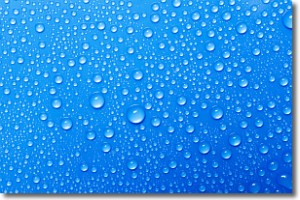
Water is always present in the air around us as a vapor, but it's too small for
us to see. When water undergoes the process of condensation it becomes organized
into visible water droplets. You've probably seen condensation happen before on the
surface of a cold drink!
Next Topic: Contrails
Weather Topic: What are Cumulonimbus Clouds?
Home - Education - Cloud Types - Cumulonimbus Clouds
 Next Topic: Cumulus Clouds
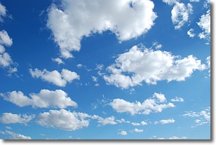
The final form taken by a growing cumulus cloud is the
cumulonimbus cloud, which is very tall and dense.
The tower of a cumulonimbus cloud can soar 23 km into the atmosphere, although
most commonly they stop growing at an altitude of 6 km.
Even small cumulonimbus clouds appear very large in comparison to other cloud types.
They can signal the approach of stormy weather, such as thunderstorms or blizzards.
Next Topic: Cumulus Clouds
Current conditions powered by WeatherAPI.com


