Weather Alert in Maine
Winter Storm Warning issued February 22 at 1:37AM EST until February 23 at 10:00PM EST by NWS Gray ME
AREAS AFFECTED: Interior York; Coastal York; Coastal Cumberland; Strafford; Cheshire; Eastern Hillsborough; Interior Rockingham; Western And Central Hillsborough
DESCRIPTION: * WHAT...Heavy snow expected. Total snow accumulations between 7 and 14 inches. Winds gusting as high as 40 mph. * WHERE...Portions of southwest Maine and central and southern New Hampshire. * WHEN...From 7 PM this evening to 10 PM EST Monday. * IMPACTS...A snowstorm will bring plowable snow to the region with a period of moderate travel impacts expected. Periods of moderate snow and low visibility will be the biggest hazards. The potential exists for snowbands that will bring periods of locally heavy snowfall, which will lead to rapid snow accumulations and extremely dangerous travel conditions. Significant snowfall and periods of heavy snowfall rates will combine with low visibility to create very dangerous driving conditions. Areas of blowing snow could significantly reduce visibility. The hazardous conditions could impact the Monday morning and evening commutes. Gusty winds will blow around unsecured objects and break some tree limbs. The power outage threat is limited.
INSTRUCTION: If you must travel, keep an extra flashlight, food, and water in your vehicle in case of an emergency. The latest road conditions can be obtained by going to newengland511.org Persons should consider delaying all travel. Motorists should use extreme caution if travel is absolutely necessary.
Want more detail? Get the Complete 7 Day and Night Detailed Forecast!
Current U.S. National Radar--Current
The Current National Weather Radar is shown below with a UTC Time (subtract 5 hours from UTC to get Eastern Time).

National Weather Forecast--Current
The Current National Weather Forecast and National Weather Map are shown below.

National Weather Forecast for Tomorrow
Tomorrow National Weather Forecast and Tomorrow National Weather Map are show below.

North America Water Vapor (Moisture)
This map shows recent moisture content over North America. Bright and colored areas show high moisture (ie, clouds); brown indicates very little moisture present; black indicates no moisture.

Weather Topic: What is Freezing Rain?
Home - Education - Precipitation - Freezing Rain
 Next Topic: Graupel
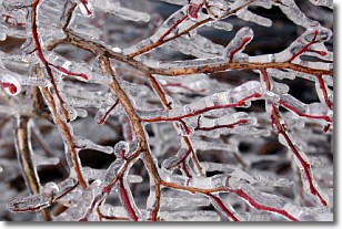
Freezing rain is a condition where precipitation which has fallen in the form of
water droplets reaches temperatures which are below freezing and freezes upon
coming into contact
with surface objects. The result of this precipitation is a glaze of ice which
can be damaging to plants and man-made structures. A severe onset of freezing
rain which results in a very thick glaze of ice is known as an ice storm.
Next Topic: Graupel
Weather Topic: What is Hail?
Home - Education - Precipitation - Hail
 Next Topic: Hole Punch Clouds
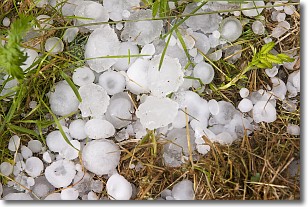
Hail is a form of precipitation which is recognized by large solid balls or
clumps of ice. Hail is created by thunderstorm clouds with strong updrafts of wind.
As the hailstones remain in the updraft, ice is deposited onto them until their
weight becomes heavy enough for them to fall to the earth's surface.
Hail storms can cause significant damage to crops, aircrafts, and man-made structures,
despite the fact that the duration is usually less than ten minutes.
Next Topic: Hole Punch Clouds
Current conditions powered by WeatherAPI.com


