Weather Alert in Illinois
Flood Warning issued April 3 at 12:49AM EDT by NWS Indianapolis IN
AREAS AFFECTED: Clark, IL; Crawford, IL; Sullivan, IN; Vigo, IN
DESCRIPTION: ...The Flood Warning continues for the following rivers in Indiana and Illinois... Wabash River from Lafayette to Hutsonville. .Multiple rounds of rainfall will bring minor lowland flooding to the Wabash River basin that could hang around through much of next week. The current river forecasts include around an inch of rainfall through Saturday morning, but do not include rainfall from Saturday through Sunday. Higher rainfall amounts in the Wabash basin could increase crests or lengthen the amount of time in flood. * WHAT...Minor flooding is forecast. * WHERE...Wabash River at Terre Haute. * WHEN...From this afternoon until further notice. * IMPACTS...At 22.5 feet, Extensive flooding behind Honey Creek Levee as a result of two unrepaired levee breaks from the April 2013 flood. This levee is maintained by the Honey Creek Levee Association. Flood waters behind the Honey Creek levee inundates most roads and affects a few residences and or commercial activities. * ADDITIONAL DETAILS... - At 12:30 AM EDT Friday /11:30 PM CDT Thursday/ the stage was 14.3 feet. - Forecast...The river is expected to rise above flood stage late this afternoon and continue rising to a crest of 23.0 feet Tuesday evening. - Flood stage is 16.5 feet. - http://www.weather.gov/safety/flood
INSTRUCTION: Motorists should not attempt to drive around barricades or drive cars through flooded areas. Be especially cautious at night when it is harder to recognize the dangers of flooding. Turn around, don't drown when encountering flooded roads. Most flood deaths occur in vehicles. Additional information is available at www.weather.gov/ind. The next statement should be issued this afternoon by around 145 PM EDT /1245 PM CDT/.
Want more detail? Get the Complete 7 Day and Night Detailed Forecast!
Current U.S. National Radar--Current
The Current National Weather Radar is shown below with a UTC Time (subtract 5 hours from UTC to get Eastern Time).

National Weather Forecast--Current
The Current National Weather Forecast and National Weather Map are shown below.

National Weather Forecast for Tomorrow
Tomorrow National Weather Forecast and Tomorrow National Weather Map are show below.

North America Water Vapor (Moisture)
This map shows recent moisture content over North America. Bright and colored areas show high moisture (ie, clouds); brown indicates very little moisture present; black indicates no moisture.

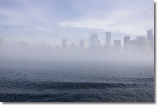
Weather Topic: What is Fog?
Home - Education - Cloud Types - Fog
 Next Topic: Fractus Clouds
Fog is technically a type of stratus cloud, which lies along the
ground and obscures visibility.
It is usually created when humidity in the air condenses into tiny water droplets.
Because of this, some places are more prone to foggy weather, such as regions
close to a body of water.
Fog is similar to mist; both are the appearance of water droplets suspended in
the air, but fog is the term applied to the condition when visibility is less than 1 km.
Next Topic: Fractus Clouds
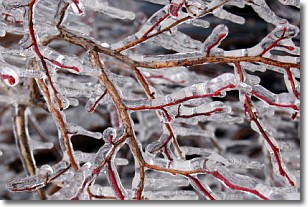
Weather Topic: What is Freezing Rain?
Home - Education - Precipitation - Freezing Rain
 Next Topic: Graupel
Freezing rain is a condition where precipitation which has fallen in the form of
water droplets reaches temperatures which are below freezing and freezes upon
coming into contact
with surface objects. The result of this precipitation is a glaze of ice which
can be damaging to plants and man-made structures. A severe onset of freezing
rain which results in a very thick glaze of ice is known as an ice storm.
Next Topic: Graupel
Current conditions powered by WeatherAPI.com


