Weather Alert in North Carolina
Special Weather Statement issued February 5 at 8:16PM EST by NWS Newport/Morehead City NC
AREAS AFFECTED: Beaufort; Mainland Hyde; Jones; Pamlico; Northern Craven; Southern Craven; West Carteret; East Carteret; Inland Onslow; Coastal Onslow
DESCRIPTION: The mix of rain, snow, sleet, and ice pellets, has further dampened the ground near the Crystal Coast this evening resulting in fairly widespread wet spots across portions of Onslow to Carteret County and areas north to Beaufort and mainland Hyde Counties. With temps quickly forecast to fall below freezing tonight, don't think these more widespread wet spots will dry in time, so black ice has become a concern. This threat will last until about 9AM before temps quickly warm above freezing and the black ice threat greatly lowers. Biggest areas of concern will be across bridges, overpasses, and any elevated roadways. Thin sheets of ice, called black ice, may be difficult to see, especially during the pre-dawn hours. They may appear to be wet spots on the road. Motorists will have a difficult time determining which spots are just wet and which are icy. Motorists are advised to use extra caution. Allow ample distance between yourself and other vehicles, to avoid the risk of a collision if slippery conditions are encountered. Allow a little extra time to reach your destination safely.
INSTRUCTION: N/A
Want more detail? Get the Complete 7 Day and Night Detailed Forecast!
Current U.S. National Radar--Current
The Current National Weather Radar is shown below with a UTC Time (subtract 5 hours from UTC to get Eastern Time).

National Weather Forecast--Current
The Current National Weather Forecast and National Weather Map are shown below.

National Weather Forecast for Tomorrow
Tomorrow National Weather Forecast and Tomorrow National Weather Map are show below.

North America Water Vapor (Moisture)
This map shows recent moisture content over North America. Bright and colored areas show high moisture (ie, clouds); brown indicates very little moisture present; black indicates no moisture.

Weather Topic: What is Hail?
Home - Education - Precipitation - Hail
 Next Topic: Hole Punch Clouds
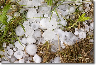
Hail is a form of precipitation which is recognized by large solid balls or
clumps of ice. Hail is created by thunderstorm clouds with strong updrafts of wind.
As the hailstones remain in the updraft, ice is deposited onto them until their
weight becomes heavy enough for them to fall to the earth's surface.
Hail storms can cause significant damage to crops, aircrafts, and man-made structures,
despite the fact that the duration is usually less than ten minutes.
Next Topic: Hole Punch Clouds
Weather Topic: What are Mammatus Clouds?
Home - Education - Cloud Types - Mammatus Clouds
 Next Topic: Nimbostratus Clouds
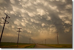
A mammatus cloud is a cloud with a unique feature which resembles
a web of pouches hanging along the base of the cloud.
In the United States, mammatus clouds tend to form in the warmer months, commonly
in the Midwest and eastern regions.
While they usually form at the bottom of a cumulonimbis cloud, they can also form
under altostratus, altocumulus, stratocumulus, and cirrus clouds. Mammatus clouds
warn that severe weather is close.
Next Topic: Nimbostratus Clouds
Current conditions powered by WeatherAPI.com


