Weather Alert in Illinois
Air Quality Alert issued September 12 at 3:10PM CDT by NWS St Louis MO
AREAS AFFECTED: Madison; St. Clair; Monroe; St. Charles; Franklin; St. Louis; St. Louis City; Jefferson
DESCRIPTION: The St. Louis Clean Air Partnership has issued an air quality alert for the St. Louis metropolitan area from 10 AM to 8 PM CDT Saturday. An Orange air quality forecast means that maximum ozone concentrations are expected to reach levels that pose a health risk. Adverse health effects increase as air quality deteriorates. Ground- level ozone is an air contaminant which can cause breathing difficulties for children, older adults, as well as persons with respiratory problems. Reducing outdoor physical activity is recommended. If it is a regularly scheduled work day you are urged to consider telecommuting, carpooling, or utilizing public transit. Avoid excessive idling and do not top off when refueling motor vehicles. The use of gasoline-powered lawn equipment should be reduced or postponed until late in the day. For more information visit the St. Louis Clean Air Partnership at http://cleanair-stlouis.com/ For current Air Quality Index (AQI) values visit https://www.airnow.gov/
INSTRUCTION: N/A
Want more detail? Get the Complete 7 Day and Night Detailed Forecast!
Current U.S. National Radar--Current
The Current National Weather Radar is shown below with a UTC Time (subtract 5 hours from UTC to get Eastern Time).

National Weather Forecast--Current
The Current National Weather Forecast and National Weather Map are shown below.

National Weather Forecast for Tomorrow
Tomorrow National Weather Forecast and Tomorrow National Weather Map are show below.

North America Water Vapor (Moisture)
This map shows recent moisture content over North America. Bright and colored areas show high moisture (ie, clouds); brown indicates very little moisture present; black indicates no moisture.

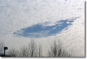
Weather Topic: What are Hole Punch Clouds?
Home - Education - Cloud Types - Hole Punch Clouds
 Next Topic: Mammatus Clouds
A hole punch cloud is an unusual occurrence when a disk-shaped
hole appears in a cirrostratus, cirrocumulus, or altocumulus cloud.
When part of the cloud forms ice crystals, water droplets in the surrounding area
of the cloud evaporate. The effect of this process produces a large elliptical
gap in the cloud. The hole punch cloud formation is rare, but it is not specific
to any geographic area.
Other names which have been used to describe this phenomena include fallstreak hole,
skypunch, and cloud hole.
Next Topic: Mammatus Clouds
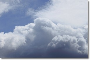
Weather Topic: What are Nimbostratus Clouds?
Home - Education - Cloud Types - Nimbostratus Clouds
 Next Topic: Precipitation
A nimbostratus cloud is similar to a stratus cloud in its formless,
smooth appearance. However, a nimbostratus cloud is darker than a stratus cloud,
because it is thicker.
Unlike a stratus cloud, a nimbostratus cloud typically brings with it the threat
of moderate to heavy precipitation. In some cases, the precipitation may evaporate
before reaching the ground, a phenomenon known as virga.
Next Topic: Precipitation
Current conditions powered by WeatherAPI.com


