Weather Alert in California
Flood Advisory issued February 24 at 3:10PM PST until February 25 at 6:27PM PST by NWS Reno NV
AREAS AFFECTED: Lassen, CA
DESCRIPTION: ...The National Weather Service in Reno has issued a Flood Advisory for the following rivers in California... Susan River At Susanville affecting Lassen County. For the Susan River near Susanville. Minor flooding is forecast. * WHAT...Minor flooding caused by rain and snowmelt is expected. * WHERE...Susan River at Susanville. * WHEN...From this evening to tomorrow night. * IMPACTS...At 12.0 feet, Flood Stage. Local flooding in Susanville from Lassen Street downstream along Riverside Drive...especially below Paiute Creek which enters river near Alexander Drive. Moderate lowland flooding below Susanville in Johnstonville... Leavitt Lake...Standish... and Litchfield areas. Some rural roads affected by flooding. While the gage is expected to fall quickly below flood stage impacts downstream near Standish will be delayed and more prolonged. * ADDITIONAL DETAILS... - At 2:30 PM PST Tuesday the stage was 7.4 feet. - Forecast...The river will rise to flood stage late this evening near midnight tonight. It will below flood stage at the gage early Wednesday morning. - Action stage is 10.5 feet. - Flood stage is 12.0 feet. - http://www.weather.gov/safety/flood
INSTRUCTION: If you are in the advisory area, remain alert to possible flooding or the possibility of the advisory being upgraded to a warning. Be cautions of nighttime flooding. Please report observed flooding to local emergency services or law enforcement and request they pass this information to the National Weather Service when you can do so safely. Additional information is available at www.weather.gov. The next statement will be issued Wednesday evening at 630 PM PST.
Want more detail? Get the Complete 7 Day and Night Detailed Forecast!
Current U.S. National Radar--Current
The Current National Weather Radar is shown below with a UTC Time (subtract 5 hours from UTC to get Eastern Time).

National Weather Forecast--Current
The Current National Weather Forecast and National Weather Map are shown below.

National Weather Forecast for Tomorrow
Tomorrow National Weather Forecast and Tomorrow National Weather Map are show below.

North America Water Vapor (Moisture)
This map shows recent moisture content over North America. Bright and colored areas show high moisture (ie, clouds); brown indicates very little moisture present; black indicates no moisture.

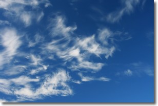
Weather Topic: What are Cirrostratus Clouds?
Home - Education - Cloud Types - Cirrostratus Clouds
 Next Topic: Cirrus Clouds
Cirrostratus clouds are high, thin clouds that form above
20,000 feet and are made mostly of ice crystals. They sometimes look like giant
feathers, horse tails, or curls of hair in the sky.
These clouds are pushed by the jet stream and can move at high speeds reaching
100 mph.
What do they indicate?
They indicate that a precipitation is likely within 24 hours.
Next Topic: Cirrus Clouds
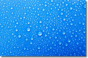
Weather Topic: What is Condensation?
Home - Education - Precipitation - Condensation
 Next Topic: Contrails
Condensation is the process which creates clouds, and therefore
it is a crucial process in the water cycle.
Condensation is the change of matter from a state of gas into a state of liquid,
and it happens because water molecules release heat into the atmosphere and
become organized into a more closely packed structure, what we might see as
water droplets.
Water is always present in the air around us as a vapor, but it's too small for
us to see. When water undergoes the process of condensation it becomes organized
into visible water droplets. You've probably seen condensation happen before on the
surface of a cold drink!
Next Topic: Contrails
Current conditions powered by WeatherAPI.com


