Weather Alert in Maine
Special Weather Statement
High Surf Advisory issued August 22 at 1:56PM EDT until August 23 at 8:00PM EDT by NWS Caribou ME
AREAS AFFECTED: Coastal Hancock; Coastal Washington
DESCRIPTION: * WHAT....Waves building to 7 to 10 feet, with a wave period of 13 to 17 seconds. Minor splashover is possible at high tide tonight. * WHERE...Coastal Hancock and Coastal Washington Counties. * WHEN...For the High Surf Advisory, until 8 PM EDT Saturday. For the Coastal Flood Statement, from 10 PM this evening to midnight EDT tonight. * IMPACTS...Rip currents and sneaker waves will lead to dangerous beach conditions. Some minor beach erosion is possible. Minor splashover possible during high tide Friday Evening. SHORELINE FLOOD IMPACTS...Building waves will cause minor splash-over on exposed coastal roads and shorelines. Pedestrians and motorists should use caution along shorelines. Large waves can present a danger to people on rocks above the water. Stay away from rock outcrops along the shoreline exposed to ocean waves...as waves can easily sweep people into the cold ocean water.
INSTRUCTION: A High Surf Advisory Means That High Surf Will Affect Beaches In The Advisory area...producing rip currents and localized beach erosion.
Want more detail? Get the Complete 7 Day and Night Detailed Forecast!
Current U.S. National Radar--Current
The Current National Weather Radar is shown below with a UTC Time (subtract 5 hours from UTC to get Eastern Time).

National Weather Forecast--Current
The Current National Weather Forecast and National Weather Map are shown below.

National Weather Forecast for Tomorrow
Tomorrow National Weather Forecast and Tomorrow National Weather Map are show below.

North America Water Vapor (Moisture)
This map shows recent moisture content over North America. Bright and colored areas show high moisture (ie, clouds); brown indicates very little moisture present; black indicates no moisture.

Weather Topic: What are Contrails?
Home - Education - Cloud Types - Contrails
 Next Topic: Cumulonimbus Clouds
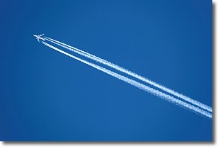
A contrail is an artificial cloud, created by the passing of an
aircraft.
Contrails form because water vapor in the exhaust of aircraft engines is suspended
in the air under certain temperatures and humidity conditions. These contrails
are called exhaust contrails.
Another type of contrail can form due to a temporary reduction in air pressure
moving over the plane's surface, causing condensation.
These are called aerodynamic contrails.
When you can see your breath on a cold day, it is also because of condensation.
The reason contrails last longer than the condensation from your breath is
because the water in contrails freezes into ice particles.
Next Topic: Cumulonimbus Clouds
Weather Topic: What are Cumulus Clouds?
Home - Education - Cloud Types - Cumulus Clouds
 Next Topic: Drizzle
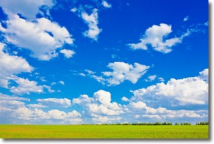
Cumulus clouds are fluffy and textured with rounded tops, and
may have flat bottoms. The border of a cumulus cloud
is clearly defined, and can have the appearance of cotton or cauliflower.
Cumulus clouds form at low altitudes (rarely above 2 km) but can grow very tall,
becoming cumulus congestus and possibly the even taller cumulonimbus clouds.
When cumulus clouds become taller, they have a greater chance of producing precipitation.
Next Topic: Drizzle
Current conditions powered by WeatherAPI.com


