Weather Alert in New York
Winter Storm Warning issued February 22 at 12:28PM EST until February 23 at 7:00PM EST by NWS Albany NY
AREAS AFFECTED: Schoharie; Western Schenectady; Eastern Schenectady; Western Albany; Eastern Albany; Western Rensselaer; Eastern Rensselaer; Bennington; Western Windham; Eastern Windham
DESCRIPTION: * WHAT...Heavy snow expected. Total snow accumulations between 4 and 10 inches across Schoharie County, the Helderbergs, Capital Region and northern Taconics of eastern New York and 6 to 12 inches across southern Vermont. Winds gusting as high as 40 mph. * WHERE...Schoharie, Schenectady, Albany and Rensselaer Counties in eastern New York and Bennington and Windham Counties in southern Vermont. * WHEN...From 7 PM this evening to 7 PM EST Monday. * IMPACTS...Travel could be difficult. Visibility will be reduced late tonight into Monday morning due to falling and blowing snow. The hazardous conditions could impact the Monday morning commute and possibly the evening commute as well for eastern areas. * ADDITIONAL DETAILS...A powerful nor'easter will impact the region this evening through Monday. There will be a sharp gradient of snowfall totals and the higher snowfall amounts will be favored across the higher elevations and southern parts of the area. Snowfall rates could approach one inch per hour within bands late tonight into Monday morning.
INSTRUCTION: If you must travel, keep an extra flashlight, food, and water in your vehicle in case of an emergency.
Want more detail? Get the Complete 7 Day and Night Detailed Forecast!
Current U.S. National Radar--Current
The Current National Weather Radar is shown below with a UTC Time (subtract 5 hours from UTC to get Eastern Time).

National Weather Forecast--Current
The Current National Weather Forecast and National Weather Map are shown below.

National Weather Forecast for Tomorrow
Tomorrow National Weather Forecast and Tomorrow National Weather Map are show below.

North America Water Vapor (Moisture)
This map shows recent moisture content over North America. Bright and colored areas show high moisture (ie, clouds); brown indicates very little moisture present; black indicates no moisture.

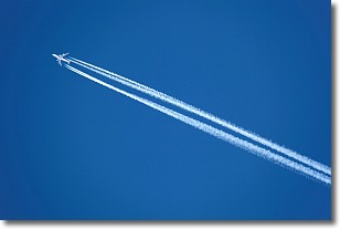
Weather Topic: What are Contrails?
Home - Education - Cloud Types - Contrails
 Next Topic: Cumulonimbus Clouds
A contrail is an artificial cloud, created by the passing of an
aircraft.
Contrails form because water vapor in the exhaust of aircraft engines is suspended
in the air under certain temperatures and humidity conditions. These contrails
are called exhaust contrails.
Another type of contrail can form due to a temporary reduction in air pressure
moving over the plane's surface, causing condensation.
These are called aerodynamic contrails.
When you can see your breath on a cold day, it is also because of condensation.
The reason contrails last longer than the condensation from your breath is
because the water in contrails freezes into ice particles.
Next Topic: Cumulonimbus Clouds
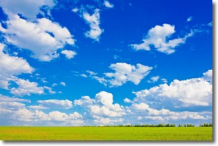
Weather Topic: What are Cumulus Clouds?
Home - Education - Cloud Types - Cumulus Clouds
 Next Topic: Drizzle
Cumulus clouds are fluffy and textured with rounded tops, and
may have flat bottoms. The border of a cumulus cloud
is clearly defined, and can have the appearance of cotton or cauliflower.
Cumulus clouds form at low altitudes (rarely above 2 km) but can grow very tall,
becoming cumulus congestus and possibly the even taller cumulonimbus clouds.
When cumulus clouds become taller, they have a greater chance of producing precipitation.
Next Topic: Drizzle
Current conditions powered by WeatherAPI.com


