Weather Alert in Michigan
Special Weather Statement issued February 5 at 7:41PM EST by NWS Gaylord MI
AREAS AFFECTED: Emmet; Cheboygan; Presque Isle; Leelanau; Antrim; Otsego; Montmorency; Alpena; Benzie; Grand Traverse; Kalkaska; Crawford; Oscoda; Alcona; Manistee; Wexford; Missaukee; Roscommon; Ogemaw; Iosco; Gladwin; Arenac; Western Chippewa; Central Chippewa; Southeast Chippewa; Western Mackinac; Eastern Mackinac; Mackinac Island/Bois Blanc Island; Beaver Island and surrounding islands; Charlevoix
DESCRIPTION: Steadiest snowfall has shifted east of I-75 across northern lower and eastern upper Michigan. In the wake of the snowfall, areas of freezing drizzle have begun to mix in west of I-75 in northern lower Michigan and portions of eastern upper Michigan. This will continue eastward toward the Lake Huron shores of northern lower Michigan this evening, with freezing drizzle potential carrying into the overnight hours until the next round of snow builds into the region from the northwest between roughly 2:00am and 6:00am. As such, a glaze of ice is possible on all untreated surfaces through the evening into tonight. Be cognizant of weather conditions if you must travel this evening into tonight, as slippery surfaces may materialize on area roads, particularly on bridges and overpasses. Remember to increase your following distance in wintry weather, and to take it slow in ice and snow!
INSTRUCTION: N/A
Want more detail? Get the Complete 7 Day and Night Detailed Forecast!
Current U.S. National Radar--Current
The Current National Weather Radar is shown below with a UTC Time (subtract 5 hours from UTC to get Eastern Time).

National Weather Forecast--Current
The Current National Weather Forecast and National Weather Map are shown below.

National Weather Forecast for Tomorrow
Tomorrow National Weather Forecast and Tomorrow National Weather Map are show below.

North America Water Vapor (Moisture)
This map shows recent moisture content over North America. Bright and colored areas show high moisture (ie, clouds); brown indicates very little moisture present; black indicates no moisture.

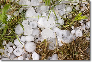
Weather Topic: What is Hail?
Home - Education - Precipitation - Hail
 Next Topic: Hole Punch Clouds
Hail is a form of precipitation which is recognized by large solid balls or
clumps of ice. Hail is created by thunderstorm clouds with strong updrafts of wind.
As the hailstones remain in the updraft, ice is deposited onto them until their
weight becomes heavy enough for them to fall to the earth's surface.
Hail storms can cause significant damage to crops, aircrafts, and man-made structures,
despite the fact that the duration is usually less than ten minutes.
Next Topic: Hole Punch Clouds
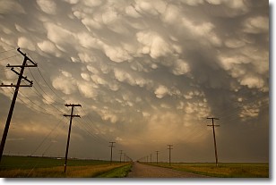
Weather Topic: What are Mammatus Clouds?
Home - Education - Cloud Types - Mammatus Clouds
 Next Topic: Nimbostratus Clouds
A mammatus cloud is a cloud with a unique feature which resembles
a web of pouches hanging along the base of the cloud.
In the United States, mammatus clouds tend to form in the warmer months, commonly
in the Midwest and eastern regions.
While they usually form at the bottom of a cumulonimbis cloud, they can also form
under altostratus, altocumulus, stratocumulus, and cirrus clouds. Mammatus clouds
warn that severe weather is close.
Next Topic: Nimbostratus Clouds
Current conditions powered by WeatherAPI.com


