Weather Alert in Alabama
Flash Flood Warning issued August 3 at 12:24AM CDT until August 3 at 1:30AM CDT by NWS Birmingham AL
AREAS AFFECTED: Calhoun, AL; Cherokee, AL; Cleburne, AL
DESCRIPTION: FFWBMX The National Weather Service in Birmingham has extended the * Flash Flood Warning for... Northeastern Calhoun County in east central Alabama... Northeastern Cleburne County in east central Alabama... Southeastern Cherokee County in northeastern Alabama... * Until 130 AM CDT. * At 1224 AM CDT, Emergency Management reported flooding from previous thunderstorms across the warned area. Between 5 and 6 inches of rain are estimated to have fallen. Flash flooding is already occurring. HAZARD...Flash flooding caused by thunderstorms. SOURCE...Emergency management reported numerous roadways across southern Cherokee County flooded, including the Spring Garden community. IMPACT...Flash flooding of small creeks and streams, urban areas, highways, streets and underpasses as well as other poor drainage and low-lying areas. * Some locations that will experience flash flooding include... Piedmont, Pleasant Gap, Borden Springs and Spring Garden.
INSTRUCTION: Turn around, don't drown when encountering flooded roads. Most flood deaths occur in vehicles. Be especially cautious at night when it is harder to recognize the dangers of flooding. Stay away or be swept away. River banks and culverts can become unstable and unsafe. Please report observed flooding to local emergency services or law enforcement and request they pass this information to the National Weather Service when you can do so safely.
Want more detail? Get the Complete 7 Day and Night Detailed Forecast!
Current U.S. National Radar--Current
The Current National Weather Radar is shown below with a UTC Time (subtract 5 hours from UTC to get Eastern Time).

National Weather Forecast--Current
The Current National Weather Forecast and National Weather Map are shown below.

National Weather Forecast for Tomorrow
Tomorrow National Weather Forecast and Tomorrow National Weather Map are show below.

North America Water Vapor (Moisture)
This map shows recent moisture content over North America. Bright and colored areas show high moisture (ie, clouds); brown indicates very little moisture present; black indicates no moisture.

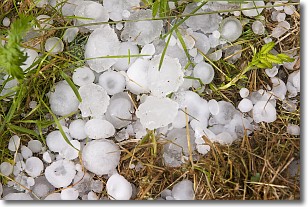
Weather Topic: What is Hail?
Home - Education - Precipitation - Hail
 Next Topic: Hole Punch Clouds
Hail is a form of precipitation which is recognized by large solid balls or
clumps of ice. Hail is created by thunderstorm clouds with strong updrafts of wind.
As the hailstones remain in the updraft, ice is deposited onto them until their
weight becomes heavy enough for them to fall to the earth's surface.
Hail storms can cause significant damage to crops, aircrafts, and man-made structures,
despite the fact that the duration is usually less than ten minutes.
Next Topic: Hole Punch Clouds
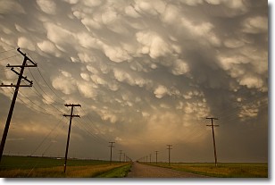
Weather Topic: What are Mammatus Clouds?
Home - Education - Cloud Types - Mammatus Clouds
 Next Topic: Nimbostratus Clouds
A mammatus cloud is a cloud with a unique feature which resembles
a web of pouches hanging along the base of the cloud.
In the United States, mammatus clouds tend to form in the warmer months, commonly
in the Midwest and eastern regions.
While they usually form at the bottom of a cumulonimbis cloud, they can also form
under altostratus, altocumulus, stratocumulus, and cirrus clouds. Mammatus clouds
warn that severe weather is close.
Next Topic: Nimbostratus Clouds
Current conditions powered by WeatherAPI.com


