Weather Alert in Washington
Red Flag Warning issued July 7 at 9:06PM PDT until July 9 at 8:00PM PDT by NWS Spokane WA
AREAS AFFECTED: Western Columbia Basin; Eastern Columbia Basin / Palouse / Spokane Area; Lower Palouse / Snake River
DESCRIPTION: ...HOT, DRY, AND WINDY TUESDAY AND WEDNESDAY... .Hot and very dry conditions will be in place on Tuesday. Winds will increase through the day with gusts 15 to 25 mph from the East Slopes to the Palouse. Locally stronger winds will develop late Tuesday afternoon and evening in the foothills of the Cascades and across the Waterville Plateau producing gusts around 30 mph. Winds will decrease Tuesday night. A dry cold front will sweep through the region on Wednesday delivering stronger winds region- wide. Humidity levels increase on Wednesday but remain near critical levels. * Affected Area: Western Columbia Basin (Zone 707), Eastern Columbia Basin -Palouse -Spokane Area (Zone 708) and Lower Palouse -Snake River (Zone 709). * Winds: Tuesday: West to southwest 10 to 20 mph with gusts to 25 mph. Wednesday: West to southwest 15 to 25 mph gusts around 40 mph. * Relative Humidities: 8 to 15 percent on Tuesday. 18 to 25 percent on Wednesday. * Impacts: Rapid fire spread is likely with any new fires.
INSTRUCTION: A Red Flag Warning means that critical fire weather conditions are either occurring now....or will shortly. A combination of strong winds...low relative humidity...and warm temperatures can contribute to extreme fire behavior.
Want more detail? Get the Complete 7 Day and Night Detailed Forecast!
Current U.S. National Radar--Current
The Current National Weather Radar is shown below with a UTC Time (subtract 5 hours from UTC to get Eastern Time).

National Weather Forecast--Current
The Current National Weather Forecast and National Weather Map are shown below.

National Weather Forecast for Tomorrow
Tomorrow National Weather Forecast and Tomorrow National Weather Map are show below.

North America Water Vapor (Moisture)
This map shows recent moisture content over North America. Bright and colored areas show high moisture (ie, clouds); brown indicates very little moisture present; black indicates no moisture.

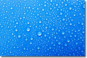
Weather Topic: What is Condensation?
Home - Education - Precipitation - Condensation
 Next Topic: Contrails
Condensation is the process which creates clouds, and therefore
it is a crucial process in the water cycle.
Condensation is the change of matter from a state of gas into a state of liquid,
and it happens because water molecules release heat into the atmosphere and
become organized into a more closely packed structure, what we might see as
water droplets.
Water is always present in the air around us as a vapor, but it's too small for
us to see. When water undergoes the process of condensation it becomes organized
into visible water droplets. You've probably seen condensation happen before on the
surface of a cold drink!
Next Topic: Contrails
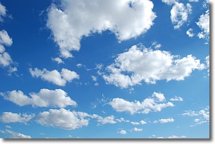
Weather Topic: What are Cumulonimbus Clouds?
Home - Education - Cloud Types - Cumulonimbus Clouds
 Next Topic: Cumulus Clouds
The final form taken by a growing cumulus cloud is the
cumulonimbus cloud, which is very tall and dense.
The tower of a cumulonimbus cloud can soar 23 km into the atmosphere, although
most commonly they stop growing at an altitude of 6 km.
Even small cumulonimbus clouds appear very large in comparison to other cloud types.
They can signal the approach of stormy weather, such as thunderstorms or blizzards.
Next Topic: Cumulus Clouds
Current conditions powered by WeatherAPI.com


