Weather Alert in Montana
Avalanche Watch issued February 22 at 6:19PM MST by NWS Missoula MT
AREAS AFFECTED: West Glacier Region
DESCRIPTION: AVAMSO The following message is transmitted at the request of the Flathead Avalanche Center Hungry Horse MT ...The Flathead Avalanche Center Hungry Horse MT has issued a Backcountry Avalanche Watch... * WHAT...An incoming storm may create exceptionally dangerous conditions. * WHERE...Flathead Range, Whitefish Range, Swan Range, and Apgar Ranges, and the Lake McDonald Valley and Marias Pass regions in Glacier National Park. * WHEN...In effect until 12 PM MST Monday * IMPACTS...If snow and strong winds arrive Monday as forecast, avalanche danger may rise to High (Level 4 of 5). New and drifted snow will overload a snowpack already producing large and very large avalanches. Many slides are being triggered from long distances away in lower-angle terrain below, near, and above steep slopes. The likelihood of natural and human- triggered avalanches will increase.
INSTRUCTION: Exceptionally dangerous avalanche conditions may develop. Travel in avalanche terrain is not recommended. Avalanches may run long distances and can run into mature forests, valley floors, or flat terrain. Consult http://www.flatheadavalanche.org for more detailed information. Similar avalanche danger may exist at locations outside the coverage area of any Avalanche Center.
Want more detail? Get the Complete 7 Day and Night Detailed Forecast!
Current U.S. National Radar--Current
The Current National Weather Radar is shown below with a UTC Time (subtract 5 hours from UTC to get Eastern Time).

National Weather Forecast--Current
The Current National Weather Forecast and National Weather Map are shown below.

National Weather Forecast for Tomorrow
Tomorrow National Weather Forecast and Tomorrow National Weather Map are show below.

North America Water Vapor (Moisture)
This map shows recent moisture content over North America. Bright and colored areas show high moisture (ie, clouds); brown indicates very little moisture present; black indicates no moisture.

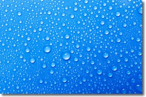
Weather Topic: What is Condensation?
Home - Education - Precipitation - Condensation
 Next Topic: Contrails
Condensation is the process which creates clouds, and therefore
it is a crucial process in the water cycle.
Condensation is the change of matter from a state of gas into a state of liquid,
and it happens because water molecules release heat into the atmosphere and
become organized into a more closely packed structure, what we might see as
water droplets.
Water is always present in the air around us as a vapor, but it's too small for
us to see. When water undergoes the process of condensation it becomes organized
into visible water droplets. You've probably seen condensation happen before on the
surface of a cold drink!
Next Topic: Contrails
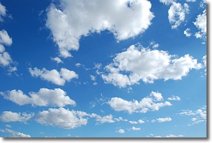
Weather Topic: What are Cumulonimbus Clouds?
Home - Education - Cloud Types - Cumulonimbus Clouds
 Next Topic: Cumulus Clouds
The final form taken by a growing cumulus cloud is the
cumulonimbus cloud, which is very tall and dense.
The tower of a cumulonimbus cloud can soar 23 km into the atmosphere, although
most commonly they stop growing at an altitude of 6 km.
Even small cumulonimbus clouds appear very large in comparison to other cloud types.
They can signal the approach of stormy weather, such as thunderstorms or blizzards.
Next Topic: Cumulus Clouds
Current conditions powered by WeatherAPI.com


