Weather Alert in Maryland
Coastal Flood Advisory issued August 21 at 9:48AM EDT until August 22 at 4:00AM EDT by NWS Baltimore MD/Washington DC
AREAS AFFECTED: Anne Arundel
DESCRIPTION: * WHAT...For the Coastal Flood Advisory, up to two feet of inundation above ground level expected in low lying areas due to tidal flooding. For the Coastal Flood Watch, two to two and half feet of inundation above ground level possible in low lying areas due to tidal flooding. * WHERE...Shoreline in Anne Arundel County. * WHEN...For the Coastal Flood Advisory, from 2 AM to 4 AM EDT Friday, especially around the time of high tide. For the Coastal Flood Watch, from late tonight through Saturday morning, especially around the time of high tide. * IMPACTS...At 3.5 feet, water reaches the floor of the Maritime Museum in Annapolis, begins to cover Bowyer Road on the Naval Academy campus, and numerous businesses on Dock Street are flooded, along with the City Dock parking lot. Bayside Beach begins to flood around Harbor Rd and Lake Dr. * ADDITIONAL DETAILS...Tides one and a half to two feet above normal. The next high tide at Annapolis U.S. Naval Academy is at 4:26 PM and 5:31 AM.
INSTRUCTION: If travel is required, allow extra time as some roads may be closed. Do not drive around barricades or through water of unknown depth. Take the necessary actions to protect flood-prone property.
Want more detail? Get the Complete 7 Day and Night Detailed Forecast!
Current U.S. National Radar--Current
The Current National Weather Radar is shown below with a UTC Time (subtract 5 hours from UTC to get Eastern Time).

National Weather Forecast--Current
The Current National Weather Forecast and National Weather Map are shown below.

National Weather Forecast for Tomorrow
Tomorrow National Weather Forecast and Tomorrow National Weather Map are show below.

North America Water Vapor (Moisture)
This map shows recent moisture content over North America. Bright and colored areas show high moisture (ie, clouds); brown indicates very little moisture present; black indicates no moisture.

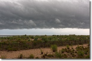
Weather Topic: What are Shelf Clouds?
Home - Education - Cloud Types - Shelf Clouds
 Next Topic: Sleet
A shelf cloud is similar to a wall cloud, but forms at the front
of a storm cloud, instead of at the rear, where wall clouds form.
A shelf cloud is caused by a series of events set into motion by the advancing
storm; first, cool air settles along the ground where precipitation has just fallen.
As the cool air is brought in, the warmer air is displaced, and rises above it,
because it is less dense. When the warmer air reaches the bottom of the storm cloud,
it begins to cool again, and the resulting condensation is a visible shelf cloud.
Next Topic: Sleet
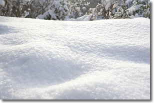
Weather Topic: What is Snow?
Home - Education - Precipitation - Snow
 Next Topic: Stratocumulus Clouds
Snow is precipitation taking the form of ice crystals. Each ice crystal, or snowflake,
has unique characteristics, but all of them grow in a hexagonal structure.
Snowfall can last for sustained periods of time and result in significant buildup
of snow on the ground.
On the earth's surface, snow starts out light and powdery, but as it begins to melt
it tends to become more granular, producing small bits of ice which have the consistency of
sand. After several cycles of melting and freezing, snow can become very dense
and ice-like, commonly known as snow pack.
Next Topic: Stratocumulus Clouds
Current conditions powered by WeatherAPI.com


