Weather Alert in Ohio
Flood Warning issued March 6 at 9:49PM EST until March 7 at 7:00AM EST by NWS Charleston WV
AREAS AFFECTED: Athens, OH; Gallia, OH; Jackson, OH; Meigs, OH; Vinton, OH; Washington, OH
DESCRIPTION: * WHAT...Flooding caused by excessive rainfall continues. * WHERE...A portion of southeast Ohio, including the following counties, Athens, Gallia, Jackson, Meigs, Vinton and Washington. * WHEN...Until 700 AM EST Saturday. * IMPACTS...Flooding of creeks and other low-lying and flood-prone locations is occurring. Low-water crossings are inundated with water and may not be passable. * ADDITIONAL DETAILS... - At 946 PM EST, several county roads remain closed due to residual flooding from area creeks, particularly in low-lying areas. Expect high water to linger overnight even though the creeks have receded to within their respective banks. This includes low-lying areas along the lower portions of the Hocking River and Shade Rivers. - Some locations that will experience flooding include... Wellston, Mcarthur, Lake Hope State Park, Middleport, and Chester. - http://www.weather.gov/safety/flood
INSTRUCTION: Turn around, don't drown when encountering flooded roads. Most flood deaths occur in vehicles. Be especially cautious at night when it is harder to recognize the dangers of flooding. In hilly terrain there are hundreds of low water crossings which are potentially dangerous in heavy rain. Do not attempt to cross flooded roads. Find an alternate route. Report flooding to the National Weather Service by calling toll free, 800 401 9535, when you can do so safely.
Want more detail? Get the Complete 7 Day and Night Detailed Forecast!
Current U.S. National Radar--Current
The Current National Weather Radar is shown below with a UTC Time (subtract 5 hours from UTC to get Eastern Time).

National Weather Forecast--Current
The Current National Weather Forecast and National Weather Map are shown below.

National Weather Forecast for Tomorrow
Tomorrow National Weather Forecast and Tomorrow National Weather Map are show below.

North America Water Vapor (Moisture)
This map shows recent moisture content over North America. Bright and colored areas show high moisture (ie, clouds); brown indicates very little moisture present; black indicates no moisture.

Weather Topic: What are Cirrus Clouds?
Home - Education - Cloud Types - Cirrus Clouds
 Next Topic: Condensation
Cirrus clouds are high-level clouds that occur above 20,000 feet
and are composed mainly of ice crystals.
They are thin and wispy in appearance.
What do they indicate?
They are often the first sign of an approaching storm.
Next Topic: Condensation
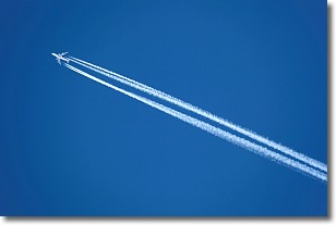
Weather Topic: What are Contrails?
Home - Education - Cloud Types - Contrails
 Next Topic: Cumulonimbus Clouds
A contrail is an artificial cloud, created by the passing of an
aircraft.
Contrails form because water vapor in the exhaust of aircraft engines is suspended
in the air under certain temperatures and humidity conditions. These contrails
are called exhaust contrails.
Another type of contrail can form due to a temporary reduction in air pressure
moving over the plane's surface, causing condensation.
These are called aerodynamic contrails.
When you can see your breath on a cold day, it is also because of condensation.
The reason contrails last longer than the condensation from your breath is
because the water in contrails freezes into ice particles.
Next Topic: Cumulonimbus Clouds
Current conditions powered by WeatherAPI.com


