Weather Alert in New York
Coastal Flood Warning issued February 22 at 3:22PM EST until February 23 at 4:00AM EST by NWS Upton NY
AREAS AFFECTED: Southwest Suffolk; Southern Nassau
DESCRIPTION: * WHAT...For the Coastal Flood Warning, 1 1/2 to 2 1/2 ft, locally 3 ft, of inundation above ground level expected in vulnerable areas near the waterfront and shoreline. For the Coastal Flood Advisory, up to 1 1/2 ft of inundation above ground level expected in vulnerable areas near the waterfront and shoreline. * WHERE...Southwest Suffolk and Southern Nassau Counties. * WHEN...For the Coastal Flood Warning, from 10 PM this evening to 4 AM EST Monday. For the Coastal Flood Advisory, from 11 AM to 6 PM EST Monday. * COASTAL FLOOD IMPACTS...Widespread moderate to localized major flooding of vulnerable areas near the waterfront and shoreline likely. Expect 1 1/2 to 2 1/2 ft, locally 3 ft of inundation above ground level possible in low lying, vulnerable areas. This will result in numerous road closures and cause widespread flooding of low lying property including parking lots, parks, lawns and homes/businesses with basements near the waterfront. Vehicles parked in vulnerable areas near the waterfront will likely become flooded. Flooding will also extend inland from the waterfront along tidal rivers and bays. Ice cover in the bays and harbors could exacerbate flooding and cause damage to northeast to east facing shoreline structures. * SHORELINE IMPACTS...Breaking surf of 5 to 10 ft along the ocean front will cause widespread beach flooding and erosion during the time of high tide. Areas of dune erosion are likely, with localized washovers possible where dunes are compromised. * ADDITIONAL DETAILS...This water level forecast has been leaned towards a high end scenario, providing a margin of safety. It is highly dependent on timing of windshift from northeast to north storm force winds with respect to the time of high tide. If shift to northerly winds occurs earlier than time of high tide, water levels will fall to the low end or even below the forecast range. Ice cover in the bays and harbors could exacerbate flooding and cause damage to north to northeast facing shoreline structures. Additional minor to locally moderate coastal flooding is likely with the Monday afternoon high tide.
INSTRUCTION: Take the necessary actions to protect flood-prone property. If travel is required, do not drive around barricades or through water of unknown depth.
Want more detail? Get the Complete 7 Day and Night Detailed Forecast!
Current U.S. National Radar--Current
The Current National Weather Radar is shown below with a UTC Time (subtract 5 hours from UTC to get Eastern Time).

National Weather Forecast--Current
The Current National Weather Forecast and National Weather Map are shown below.

National Weather Forecast for Tomorrow
Tomorrow National Weather Forecast and Tomorrow National Weather Map are show below.

North America Water Vapor (Moisture)
This map shows recent moisture content over North America. Bright and colored areas show high moisture (ie, clouds); brown indicates very little moisture present; black indicates no moisture.

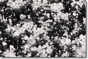
Weather Topic: What is Graupel?
Home - Education - Precipitation - Graupel
 Next Topic: Hail
Graupel is a form of precipitation that is created by atmospheric conditions
which cause supercooled water droplets to contact snow crystals and freeze to
their surface.
Sometimes known as soft hail or snow pellets, graupel is delicate and easily
destroyed by touch. Whereas hail usually falls during severe weather, graupel
doesn't require such conditions to form, and can form in mild precipitation
similar to situations which produce snowfall.
Next Topic: Hail
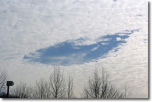
Weather Topic: What are Hole Punch Clouds?
Home - Education - Cloud Types - Hole Punch Clouds
 Next Topic: Mammatus Clouds
A hole punch cloud is an unusual occurrence when a disk-shaped
hole appears in a cirrostratus, cirrocumulus, or altocumulus cloud.
When part of the cloud forms ice crystals, water droplets in the surrounding area
of the cloud evaporate. The effect of this process produces a large elliptical
gap in the cloud. The hole punch cloud formation is rare, but it is not specific
to any geographic area.
Other names which have been used to describe this phenomena include fallstreak hole,
skypunch, and cloud hole.
Next Topic: Mammatus Clouds
Current conditions powered by WeatherAPI.com


