Weather Alert in North Carolina
Cold Weather Advisory issued February 6 at 1:08PM EST until February 8 at 7:00AM EST by NWS Greenville-Spartanburg SC
AREAS AFFECTED: Yancey; Mitchell
DESCRIPTION: * WHAT...For the High Wind Warning, northwest winds 20 to 30 mph with gusts up to 55 to 60 mph, and up to 75 mph on ridgetops expected. For the Cold Weather Advisory above 3500 feet, very cold wind chills as low as 10 below expected. * WHERE...Mitchell and Yancey Counties. * WHEN...For the High Wind Warning, from 7 PM this evening to 7 PM EST Saturday. For the Cold Weather Advisory, from 1 AM Saturday to 7 AM EST Sunday. * IMPACTS...Damaging winds will blow down trees and power lines. Widespread power outages are expected. Travel will be difficult, especially for high profile vehicles. The dangerously cold wind chills as low as 20 below zero could cause frostbite on exposed skin in as little as 30 minutes. * ADDITIONAL DETAILS...A Winter Weather Advisory is also in effect for Mitchell and Yancey counties for snow accumulation through 7 am Saturday. Expect difficult travel on snow covered roads. The strong winds will result in areas of blowing snow that will sharply reduce the visibility.
INSTRUCTION: Avoid being outside near trees. If caught outside, watch for falling debris or tree limbs. Remain in the lower levels of your home during the windstorm and avoid windows and overhanging trees. Use caution if you must drive. Stay tuned to NOAA Weather Radio or your favorite source of weather information for the latest updates. Additional details can be found at www.weather.gov/gsp. Use caution while traveling outside. Wear appropriate clothing, a hat, and gloves.
Want more detail? Get the Complete 7 Day and Night Detailed Forecast!
Current U.S. National Radar--Current
The Current National Weather Radar is shown below with a UTC Time (subtract 5 hours from UTC to get Eastern Time).

National Weather Forecast--Current
The Current National Weather Forecast and National Weather Map are shown below.

National Weather Forecast for Tomorrow
Tomorrow National Weather Forecast and Tomorrow National Weather Map are show below.

North America Water Vapor (Moisture)
This map shows recent moisture content over North America. Bright and colored areas show high moisture (ie, clouds); brown indicates very little moisture present; black indicates no moisture.

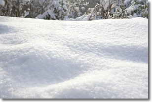
Weather Topic: What is Snow?
Home - Education - Precipitation - Snow
 Next Topic: Stratocumulus Clouds
Snow is precipitation taking the form of ice crystals. Each ice crystal, or snowflake,
has unique characteristics, but all of them grow in a hexagonal structure.
Snowfall can last for sustained periods of time and result in significant buildup
of snow on the ground.
On the earth's surface, snow starts out light and powdery, but as it begins to melt
it tends to become more granular, producing small bits of ice which have the consistency of
sand. After several cycles of melting and freezing, snow can become very dense
and ice-like, commonly known as snow pack.
Next Topic: Stratocumulus Clouds
Weather Topic: What are Stratus Clouds?
Home - Education - Cloud Types - Stratus Clouds
 Next Topic: Wall Clouds
Stratus clouds are similar to altostratus clouds, but form at a
lower altitude and are identified by their fog-like appearance, lacking the
distinguishing features of most clouds.
Stratus clouds are wider than most clouds, and their base has a smooth, uniform
look which is lighter in color than a nimbostratus cloud.
The presence of a stratus cloud indicates the possibility of minor precipitation,
such as drizzle, but heavier precipitation does not typically arrive in the form
of a stratus cloud.
Next Topic: Wall Clouds
Current conditions powered by WeatherAPI.com


