Weather Alert in Indiana
Winter Weather Advisory issued February 22 at 10:26AM CST until February 23 at 12:00PM CST by NWS Chicago IL
AREAS AFFECTED: Porter
DESCRIPTION: * WHAT...Lake effect snow causing localized hazardous travel. Additional snow accumulations in the most persistent snow showers between 2 and 4 inches, with locally higher amounts possible mainly east of State Road 49 and north of US Route 30. Winds gusting as high as 35 to 40 mph near the lakeshore. Some blowing and drifting snow is possible tonight into Monday. * WHERE...Porter County. * WHEN...Until noon CST Monday. * IMPACTS...Roads, and especially bridges and overpasses, will be slick and hazardous in spots. The hazardous conditions are expected to impact the Monday morning commute. * ADDITIONAL DETAILS...The worst conditions are expected to occur this evening into Monday morning.
INSTRUCTION: Slow down and use caution while traveling. The latest road conditions for Indiana can be obtained at https://511in.org. During lake effect snow, the weather can vary from bands of moderate to locally heavy snow to dry weather just a few miles away. Visibilities can also vary greatly. Be prepared for rapid changes in weather, visibility, and road conditions.
Want more detail? Get the Complete 7 Day and Night Detailed Forecast!
Current U.S. National Radar--Current
The Current National Weather Radar is shown below with a UTC Time (subtract 5 hours from UTC to get Eastern Time).

National Weather Forecast--Current
The Current National Weather Forecast and National Weather Map are shown below.

National Weather Forecast for Tomorrow
Tomorrow National Weather Forecast and Tomorrow National Weather Map are show below.

North America Water Vapor (Moisture)
This map shows recent moisture content over North America. Bright and colored areas show high moisture (ie, clouds); brown indicates very little moisture present; black indicates no moisture.

Weather Topic: What is Graupel?
Home - Education - Precipitation - Graupel
 Next Topic: Hail
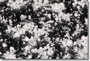
Graupel is a form of precipitation that is created by atmospheric conditions
which cause supercooled water droplets to contact snow crystals and freeze to
their surface.
Sometimes known as soft hail or snow pellets, graupel is delicate and easily
destroyed by touch. Whereas hail usually falls during severe weather, graupel
doesn't require such conditions to form, and can form in mild precipitation
similar to situations which produce snowfall.
Next Topic: Hail
Weather Topic: What are Hole Punch Clouds?
Home - Education - Cloud Types - Hole Punch Clouds
 Next Topic: Mammatus Clouds
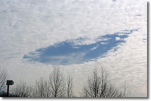
A hole punch cloud is an unusual occurrence when a disk-shaped
hole appears in a cirrostratus, cirrocumulus, or altocumulus cloud.
When part of the cloud forms ice crystals, water droplets in the surrounding area
of the cloud evaporate. The effect of this process produces a large elliptical
gap in the cloud. The hole punch cloud formation is rare, but it is not specific
to any geographic area.
Other names which have been used to describe this phenomena include fallstreak hole,
skypunch, and cloud hole.
Next Topic: Mammatus Clouds
Current conditions powered by WeatherAPI.com


