Weather Alert in New York
Special Weather Statement issued September 3 at 3:07PM EDT by NWS Burlington VT
AREAS AFFECTED: Northern Franklin; Eastern Clinton; Western Clinton; Eastern Essex; Grand Isle; Western Franklin; Orleans; Essex; Western Chittenden; Lamoille; Caledonia; Washington; Western Addison; Orange; Western Rutland; Eastern Franklin; Eastern Chittenden; Eastern Addison; Eastern Rutland; Western Windsor; Eastern Windsor
DESCRIPTION: Fine fuels remain very dry across the area, particularly across the Connecticut and Champlain Valleys, according to the Vermont Department of Forests, Parks and Recreation and the New York State Department of Environmental Conservation. Portions of central and northern Vermont and parts of northern New York also remain in moderate drought. Southerly winds will quickly increase to 10 to 15 MPH with gusts up to 25 MPH possible across Vermont. Localized gusts up to 35 MPH are possible particularly in the north to south oriented valleys of the Champlain Valley and portions of northern New York. This, combined with expected low relative humidity values between 25% to 35% will create near critical fire weather conditions Thursday. Winds will be strongest between noon and 8 PM, coinciding with the timing of the minimum relative humidity values. If any fires were to start the weather and fuel conditions could cause fires to quickly get out of control and be difficult to contain. Fire weather conditions areawide will quickly improve as confidence increases in wetting rainfall Thursday night. For more information about the current fire danger rating, any burn restrictions, and wildfire prevention and education, please visit your state forestry or environmental protection website.
INSTRUCTION: N/A
Want more detail? Get the Complete 7 Day and Night Detailed Forecast!
Current U.S. National Radar--Current
The Current National Weather Radar is shown below with a UTC Time (subtract 5 hours from UTC to get Eastern Time).

National Weather Forecast--Current
The Current National Weather Forecast and National Weather Map are shown below.

National Weather Forecast for Tomorrow
Tomorrow National Weather Forecast and Tomorrow National Weather Map are show below.

North America Water Vapor (Moisture)
This map shows recent moisture content over North America. Bright and colored areas show high moisture (ie, clouds); brown indicates very little moisture present; black indicates no moisture.

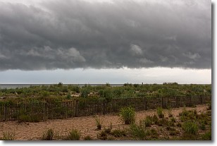
Weather Topic: What are Shelf Clouds?
Home - Education - Cloud Types - Shelf Clouds
 Next Topic: Sleet
A shelf cloud is similar to a wall cloud, but forms at the front
of a storm cloud, instead of at the rear, where wall clouds form.
A shelf cloud is caused by a series of events set into motion by the advancing
storm; first, cool air settles along the ground where precipitation has just fallen.
As the cool air is brought in, the warmer air is displaced, and rises above it,
because it is less dense. When the warmer air reaches the bottom of the storm cloud,
it begins to cool again, and the resulting condensation is a visible shelf cloud.
Next Topic: Sleet
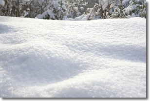
Weather Topic: What is Snow?
Home - Education - Precipitation - Snow
 Next Topic: Stratocumulus Clouds
Snow is precipitation taking the form of ice crystals. Each ice crystal, or snowflake,
has unique characteristics, but all of them grow in a hexagonal structure.
Snowfall can last for sustained periods of time and result in significant buildup
of snow on the ground.
On the earth's surface, snow starts out light and powdery, but as it begins to melt
it tends to become more granular, producing small bits of ice which have the consistency of
sand. After several cycles of melting and freezing, snow can become very dense
and ice-like, commonly known as snow pack.
Next Topic: Stratocumulus Clouds
Current conditions powered by WeatherAPI.com


