Weather Alert in Arkansas
Severe Thunderstorm Warning issued September 5 at 10:30PM CDT until September 5 at 11:30PM CDT by NWS Shreveport LA
AREAS AFFECTED: Little River, AR; Sevier, AR; McCurtain, OK; Bowie, TX; Red River, TX
DESCRIPTION: SVRSHV The National Weather Service in Shreveport has issued a * Severe Thunderstorm Warning for... Northwestern Little River County in southwestern Arkansas... Western Sevier County in southwestern Arkansas... McCurtain County in southeastern Oklahoma... Northwestern Bowie County in northeastern Texas... Northeastern Red River County in northeastern Texas... * Until 1130 PM CDT. * At 1030 PM CDT, severe thunderstorms were located along a line from 28 miles northwest of Broken Bow to 11 miles west of Arkinda, or along a line from 43 miles northwest of De Queen to 14 miles west of Foreman, moving northeast at 30 mph. HAZARD...60 mph wind gusts and quarter size hail. SOURCE...Radar indicated. IMPACT...Hail damage to vehicles is expected. Expect wind damage to roofs, siding, and trees. * Locations impacted include... De Queen, Horatio, Foreman, Idabel, Broken Bow, Lockesburg, Winthrop, Arkinda, Wright City, Millerton, Annona, Haworth, Garvin, Eagletown, Oak Hill, Holly Creek, Hochatown, Goodwater, Golden and Glover.
INSTRUCTION: Seek shelter inside a well-built structure and stay away from windows. These storms are capable of producing damaging winds and large hail. Continuous cloud to ground lightning is occurring with these storms. Lightning is one of nature's leading killers. Remember, if you can hear thunder, you are close enough to be struck by lightning. Wind damage with these storms will occur before any rain or lightning. Do not wait for the sound of thunder before taking cover. Seek shelter immediately inside a sturdy structure and stay away from windows. Torrential rainfall is also occurring with these storms and may lead to flash flooding. Do not drive your vehicle through flooded roadways.
Want more detail? Get the Complete 7 Day and Night Detailed Forecast!
Current U.S. National Radar--Current
The Current National Weather Radar is shown below with a UTC Time (subtract 5 hours from UTC to get Eastern Time).

National Weather Forecast--Current
The Current National Weather Forecast and National Weather Map are shown below.

National Weather Forecast for Tomorrow
Tomorrow National Weather Forecast and Tomorrow National Weather Map are show below.

North America Water Vapor (Moisture)
This map shows recent moisture content over North America. Bright and colored areas show high moisture (ie, clouds); brown indicates very little moisture present; black indicates no moisture.

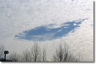
Weather Topic: What are Hole Punch Clouds?
Home - Education - Cloud Types - Hole Punch Clouds
 Next Topic: Mammatus Clouds
A hole punch cloud is an unusual occurrence when a disk-shaped
hole appears in a cirrostratus, cirrocumulus, or altocumulus cloud.
When part of the cloud forms ice crystals, water droplets in the surrounding area
of the cloud evaporate. The effect of this process produces a large elliptical
gap in the cloud. The hole punch cloud formation is rare, but it is not specific
to any geographic area.
Other names which have been used to describe this phenomena include fallstreak hole,
skypunch, and cloud hole.
Next Topic: Mammatus Clouds
Weather Topic: What are Nimbostratus Clouds?
Home - Education - Cloud Types - Nimbostratus Clouds
 Next Topic: Precipitation
A nimbostratus cloud is similar to a stratus cloud in its formless,
smooth appearance. However, a nimbostratus cloud is darker than a stratus cloud,
because it is thicker.
Unlike a stratus cloud, a nimbostratus cloud typically brings with it the threat
of moderate to heavy precipitation. In some cases, the precipitation may evaporate
before reaching the ground, a phenomenon known as virga.
Next Topic: Precipitation
Current conditions powered by WeatherAPI.com


