Weather Alert in Idaho
Flash Flood Warning issued August 26 at 6:05PM MDT until August 26 at 9:00PM MDT by NWS Boise ID
AREAS AFFECTED: Boise, ID
DESCRIPTION: FFWBOI The National Weather Service in Boise has issued a * Flash Flood Warning for... East Central Boise County in southwestern Idaho... * Until 900 PM MDT. * At 605 PM MDT, Boise County law enforcement reported numerous 911 calls about rock slides and standing water on Idaho State Highway 21 between Lowman and Grandjean. Flash flooding is ongoing. HAZARD...Flash flooding caused by thunderstorms. SOURCE...Law enforcement reported. IMPACT...Flash flooding of small creeks and streams, as well as other poor drainage and low-lying areas. Rock slides were reported on Idaho State Highway 21 at mileposts 72 and 76-77. Three feet of water was reported on the road at milepost 80.
INSTRUCTION: Stay away or be swept away. River banks and culverts can become unstable and unsafe. In hilly terrain there are hundreds of low water crossings which are potentially dangerous in heavy rain. Do not attempt to cross flooded roads. Find an alternate route.
Want more detail? Get the Complete 7 Day and Night Detailed Forecast!
Current U.S. National Radar--Current
The Current National Weather Radar is shown below with a UTC Time (subtract 5 hours from UTC to get Eastern Time).

National Weather Forecast--Current
The Current National Weather Forecast and National Weather Map are shown below.

National Weather Forecast for Tomorrow
Tomorrow National Weather Forecast and Tomorrow National Weather Map are show below.

North America Water Vapor (Moisture)
This map shows recent moisture content over North America. Bright and colored areas show high moisture (ie, clouds); brown indicates very little moisture present; black indicates no moisture.

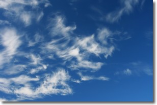
Weather Topic: What are Cirrostratus Clouds?
Home - Education - Cloud Types - Cirrostratus Clouds
 Next Topic: Cirrus Clouds
Cirrostratus clouds are high, thin clouds that form above
20,000 feet and are made mostly of ice crystals. They sometimes look like giant
feathers, horse tails, or curls of hair in the sky.
These clouds are pushed by the jet stream and can move at high speeds reaching
100 mph.
What do they indicate?
They indicate that a precipitation is likely within 24 hours.
Next Topic: Cirrus Clouds
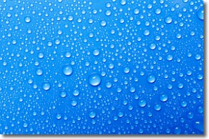
Weather Topic: What is Condensation?
Home - Education - Precipitation - Condensation
 Next Topic: Contrails
Condensation is the process which creates clouds, and therefore
it is a crucial process in the water cycle.
Condensation is the change of matter from a state of gas into a state of liquid,
and it happens because water molecules release heat into the atmosphere and
become organized into a more closely packed structure, what we might see as
water droplets.
Water is always present in the air around us as a vapor, but it's too small for
us to see. When water undergoes the process of condensation it becomes organized
into visible water droplets. You've probably seen condensation happen before on the
surface of a cold drink!
Next Topic: Contrails
Current conditions powered by WeatherAPI.com


