Weather Alert in Illinois
Flood Warning issued April 3 at 3:01PM CDT until April 5 at 4:00PM CDT by NWS Chicago IL
AREAS AFFECTED: Winnebago, IL
DESCRIPTION: ...The National Weather Service in Chicago IL has issued a Flood Warning for the following rivers in Illinois... Kishwaukee River near Perryville affecting Winnebago County. For the Kishwaukee River...including Perryville...Minor flooding is forecast. * WHAT...Minor flooding is forecast. * WHERE...Kishwaukee River from Confluence with South Branch Kishwaukee River downstream to the Rock River, including the Perryville gauge. * WHEN...Until Sunday afternoon. * IMPACTS...At 13.0 feet, Roadways threatened at Blackhawk Valley Campground south of Rockford. * ADDITIONAL DETAILS... - At 2:30 PM CDT Friday the stage was 11.8 feet. - Forecast...The river is expected to rise above flood stage this evening to a crest of 12.7 feet tomorrow evening. It will then fall below flood stage late Sunday morning. - Flood stage is 12.0 feet. - http://www.weather.gov/safety/flood
INSTRUCTION: A Flood Warning means water levels above flood stage are imminent or may already be occurring. Persons along rivers and streams in the warned area should take immediate precautions to protect life and property. These forecasts are based on observed precipitation as well as forecast precipitation 24 hours into the future. Changes to the rainfall forecast, or any additional rainfall after 24 hours, may cause changes to these river forecasts. Additional information is available at www.weather.gov. The next statement will be issued by Saturday morning.
Want more detail? Get the Complete 7 Day and Night Detailed Forecast!
Current U.S. National Radar--Current
The Current National Weather Radar is shown below with a UTC Time (subtract 5 hours from UTC to get Eastern Time).

National Weather Forecast--Current
The Current National Weather Forecast and National Weather Map are shown below.

National Weather Forecast for Tomorrow
Tomorrow National Weather Forecast and Tomorrow National Weather Map are show below.

North America Water Vapor (Moisture)
This map shows recent moisture content over North America. Bright and colored areas show high moisture (ie, clouds); brown indicates very little moisture present; black indicates no moisture.

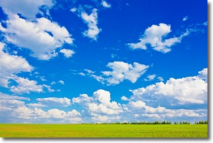
Weather Topic: What are Cumulus Clouds?
Home - Education - Cloud Types - Cumulus Clouds
 Next Topic: Drizzle
Cumulus clouds are fluffy and textured with rounded tops, and
may have flat bottoms. The border of a cumulus cloud
is clearly defined, and can have the appearance of cotton or cauliflower.
Cumulus clouds form at low altitudes (rarely above 2 km) but can grow very tall,
becoming cumulus congestus and possibly the even taller cumulonimbus clouds.
When cumulus clouds become taller, they have a greater chance of producing precipitation.
Next Topic: Drizzle
Weather Topic: What is Evaporation?
Home - Education - Precipitation - Evaporation
 Next Topic: Fog
Evaporation is the process which returns water from the earth
back to the atmosphere, and is another crucial process in the water cycle.
Evaporation is the transformation of liquid into gas, and it happens because
molecules are excited by the application of energy and turn into vapor.
In order for water to evaporate it has to be on the surface of a body of water.
Next Topic: Fog
Current conditions powered by WeatherAPI.com


