Weather Alert in New York
Winter Weather Advisory issued February 22 at 12:50PM EST until February 24 at 6:00AM EST by NWS Buffalo NY
AREAS AFFECTED: Wyoming; Cattaraugus; Southern Erie
DESCRIPTION: * WHAT...Snow expected. Total snow accumulations of 4 to 8 inches across the higher terrain of the Boston Hills, ridges of Wyoming County, and northern Cattaraugus County. Accumulations will be much lower in the valleys and lower elevations, where only 2 to 4 inches is expected. * WHERE...Wyoming, Cattaraugus, and Southern Erie Counties. The greatest accumulations will be across higher terrain. * WHEN...From 7 PM this evening to 6 AM EST Tuesday. * IMPACTS...Travel will be difficult at times with snow covered roads and reduced visibility. The hazardous conditions will impact the Monday morning and evening commutes.
INSTRUCTION: Periods of snow will result in snow covered roads and limited visibilities. Slow down and use caution while driving. Submit snow reports through our website or social media.
Want more detail? Get the Complete 7 Day and Night Detailed Forecast!
Current U.S. National Radar--Current
The Current National Weather Radar is shown below with a UTC Time (subtract 5 hours from UTC to get Eastern Time).

National Weather Forecast--Current
The Current National Weather Forecast and National Weather Map are shown below.

National Weather Forecast for Tomorrow
Tomorrow National Weather Forecast and Tomorrow National Weather Map are show below.

North America Water Vapor (Moisture)
This map shows recent moisture content over North America. Bright and colored areas show high moisture (ie, clouds); brown indicates very little moisture present; black indicates no moisture.

Weather Topic: What is Graupel?
Home - Education - Precipitation - Graupel
 Next Topic: Hail
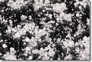
Graupel is a form of precipitation that is created by atmospheric conditions
which cause supercooled water droplets to contact snow crystals and freeze to
their surface.
Sometimes known as soft hail or snow pellets, graupel is delicate and easily
destroyed by touch. Whereas hail usually falls during severe weather, graupel
doesn't require such conditions to form, and can form in mild precipitation
similar to situations which produce snowfall.
Next Topic: Hail
Weather Topic: What are Hole Punch Clouds?
Home - Education - Cloud Types - Hole Punch Clouds
 Next Topic: Mammatus Clouds
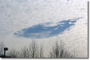
A hole punch cloud is an unusual occurrence when a disk-shaped
hole appears in a cirrostratus, cirrocumulus, or altocumulus cloud.
When part of the cloud forms ice crystals, water droplets in the surrounding area
of the cloud evaporate. The effect of this process produces a large elliptical
gap in the cloud. The hole punch cloud formation is rare, but it is not specific
to any geographic area.
Other names which have been used to describe this phenomena include fallstreak hole,
skypunch, and cloud hole.
Next Topic: Mammatus Clouds
Current conditions powered by WeatherAPI.com


