Weather Alert in Texas
Flood Watch issued August 14 at 3:42PM CDT until August 15 at 6:00PM CDT by NWS Brownsville TX
AREAS AFFECTED: Southern Hidalgo; Inland Cameron; Coastal Cameron; Cameron Island
DESCRIPTION: Tropical moisture related to Invest 98L could bring locally heavy rainfall possibly enhanced by organized convection could lead to possible isolated to scattered urban poor drainage flooding to Cameron and Southern Hidalgo counties along the Rio Grande Valley on Friday. * WHAT...Flooding caused by excessive rainfall is possible. * WHERE...A portion of Deep South Texas, including the following areas, Cameron Island, Coastal Cameron, Inland Cameron and Southern Hidalgo. * WHEN...From Friday morning through Friday afternoon. * IMPACTS...Excessive runoff may result in flooding of roadways as well as other low-lying and flood-prone locations. Flooding may occur in poor drainage and urban areas. * ADDITIONAL DETAILS... - While there is a higher than usual degree of uncertainty with the evolution of Invest 98L, there is the potential for organized convection to impact somewhere across the Lower Texas Coast. The resultant heavy rainfall could lead to possible isolated to scattered urban poor drainage flooding across Cameron and Southern Hidalgo counties on Friday. - http://www.weather.gov/safety/flood
INSTRUCTION: You should monitor later forecasts and be alert for possible Flood Warnings. Those living in areas prone to flooding should be prepared to take action should flooding develop.
Want more detail? Get the Complete 7 Day and Night Detailed Forecast!
Current U.S. National Radar--Current
The Current National Weather Radar is shown below with a UTC Time (subtract 5 hours from UTC to get Eastern Time).

National Weather Forecast--Current
The Current National Weather Forecast and National Weather Map are shown below.

National Weather Forecast for Tomorrow
Tomorrow National Weather Forecast and Tomorrow National Weather Map are show below.

North America Water Vapor (Moisture)
This map shows recent moisture content over North America. Bright and colored areas show high moisture (ie, clouds); brown indicates very little moisture present; black indicates no moisture.

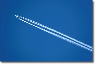
Weather Topic: What are Contrails?
Home - Education - Cloud Types - Contrails
 Next Topic: Cumulonimbus Clouds
A contrail is an artificial cloud, created by the passing of an
aircraft.
Contrails form because water vapor in the exhaust of aircraft engines is suspended
in the air under certain temperatures and humidity conditions. These contrails
are called exhaust contrails.
Another type of contrail can form due to a temporary reduction in air pressure
moving over the plane's surface, causing condensation.
These are called aerodynamic contrails.
When you can see your breath on a cold day, it is also because of condensation.
The reason contrails last longer than the condensation from your breath is
because the water in contrails freezes into ice particles.
Next Topic: Cumulonimbus Clouds
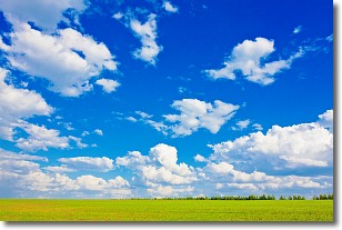
Weather Topic: What are Cumulus Clouds?
Home - Education - Cloud Types - Cumulus Clouds
 Next Topic: Drizzle
Cumulus clouds are fluffy and textured with rounded tops, and
may have flat bottoms. The border of a cumulus cloud
is clearly defined, and can have the appearance of cotton or cauliflower.
Cumulus clouds form at low altitudes (rarely above 2 km) but can grow very tall,
becoming cumulus congestus and possibly the even taller cumulonimbus clouds.
When cumulus clouds become taller, they have a greater chance of producing precipitation.
Next Topic: Drizzle
Current conditions powered by WeatherAPI.com


