Weather Alert in Alaska
Flood Watch issued September 2 at 7:41AM AKDT until September 7 at 10:00AM AKDT by NWS Anchorage AK
AREAS AFFECTED: NW Kenai Peninsula; Skilak Lake
DESCRIPTION: * WHAT...Flooding caused by the Skilak glacier-dammed lake release is possible. * WHERE...Skilak Lake and the Middle Kenai River near Skilak Lake and the Kenai River Downstream of Skilak Lake. * WHEN...Through Sunday morning. * IMPACTS...Kenai River level forecasts: Currently expecting the Kenai River to rise steadily at Skilak Lake outlet another 2 feet, cresting at moderate flood stage Friday or Saturday. At the Kenai Keys, expecting the Kenai River to rise another 2 to 2.5 feet, cresting just below moderate flood stage of 12 feet Friday or Saturday. Down river at Soldotna, expecting the Kenai River to rise steadily through week, cresting Saturday above bankfull levels near 12 feet. IMPACTS: Expect steady river level increases next 4 days on lower Kenai River. Flooding of low lying areas in the Kenai Keys area, boat dock issues and extended period of high water and bankfull conditions is likely. Excessive runoff may result in flooding of rivers, creeks, streams, and other low-lying and flood-prone locations. * ADDITIONAL DETAILS... - Skilak Glacier Dam Lake is likely releasing. This combined with recent significant rain in the upper Kenai River basin will cause Kenai river levels to rise steadily from the outlet of Skilak Lake to the mouth through the end of this week. Some uncertainty exists due to recent rain as to when the Skilak Glacier Dam lake began releasing which could impact the crest timing and height. Planned aerial reconnaissance of Skilak Glacier Dam Lake will confirm whether a release has taken place and the extent of any release. - Http://www.weather.gov/safety/flood
INSTRUCTION: You should monitor later forecasts and be alert for possible Flood Warnings. Those living in areas prone to flooding should be prepared to take action should flooding develop. Stay tuned to further developments by listening to your local radio, television, or NOAA Weather Radio for further information.
Want more detail? Get the Complete 7 Day and Night Detailed Forecast!
Current U.S. National Radar--Current
The Current National Weather Radar is shown below with a UTC Time (subtract 5 hours from UTC to get Eastern Time).

National Weather Forecast--Current
The Current National Weather Forecast and National Weather Map are shown below.

National Weather Forecast for Tomorrow
Tomorrow National Weather Forecast and Tomorrow National Weather Map are show below.

North America Water Vapor (Moisture)
This map shows recent moisture content over North America. Bright and colored areas show high moisture (ie, clouds); brown indicates very little moisture present; black indicates no moisture.

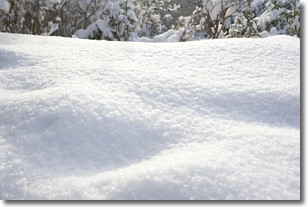
Weather Topic: What is Snow?
Home - Education - Precipitation - Snow
 Next Topic: Stratocumulus Clouds
Snow is precipitation taking the form of ice crystals. Each ice crystal, or snowflake,
has unique characteristics, but all of them grow in a hexagonal structure.
Snowfall can last for sustained periods of time and result in significant buildup
of snow on the ground.
On the earth's surface, snow starts out light and powdery, but as it begins to melt
it tends to become more granular, producing small bits of ice which have the consistency of
sand. After several cycles of melting and freezing, snow can become very dense
and ice-like, commonly known as snow pack.
Next Topic: Stratocumulus Clouds
Weather Topic: What are Stratus Clouds?
Home - Education - Cloud Types - Stratus Clouds
 Next Topic: Wall Clouds
Stratus clouds are similar to altostratus clouds, but form at a
lower altitude and are identified by their fog-like appearance, lacking the
distinguishing features of most clouds.
Stratus clouds are wider than most clouds, and their base has a smooth, uniform
look which is lighter in color than a nimbostratus cloud.
The presence of a stratus cloud indicates the possibility of minor precipitation,
such as drizzle, but heavier precipitation does not typically arrive in the form
of a stratus cloud.
Next Topic: Wall Clouds
Current conditions powered by WeatherAPI.com


