Weather Alert in New York
Winter Weather Advisory issued February 5 at 12:44PM EST until February 7 at 7:00PM EST by NWS Buffalo NY
AREAS AFFECTED: Niagara; Orleans; Northern Erie; Genesee; Wyoming; Chautauqua; Cattaraugus; Southern Erie
DESCRIPTION: * WHAT...A combination of widespread snow and localized lake effect snow expected. Total snow accumulations 3 to 6 inches expected, with locally higher amounts possible across the hilltops south of Buffalo. Winds gusting as high as 40 mph will create areas of blowing and drifting snow. * WHERE...Erie, Niagara, Orleans, Genesee, Wyoming, Chautauqua, and Cattaraugus Counties. * WHEN...From 7 AM Friday to 7 PM EST Saturday. * IMPACTS...Travel will be difficult. The hazardous conditions will impact the Friday evening commute. * ADDITIONAL DETAILS...An Arctic front will bring widespread snow showers to the region Friday morning, which will then taper off to more localized lake effect snow Friday night through Saturday. Winds strengthening behind this front late Friday evening through Saturday will resulting of blowing and drifting of the fresh snowpack.
INSTRUCTION: Periods of snow will result in snow covered roads and limited visibilities. Slow down and use caution while driving. Submit snow reports through our website or social media.
Want more detail? Get the Complete 7 Day and Night Detailed Forecast!
Current U.S. National Radar--Current
The Current National Weather Radar is shown below with a UTC Time (subtract 5 hours from UTC to get Eastern Time).

National Weather Forecast--Current
The Current National Weather Forecast and National Weather Map are shown below.

National Weather Forecast for Tomorrow
Tomorrow National Weather Forecast and Tomorrow National Weather Map are show below.

North America Water Vapor (Moisture)
This map shows recent moisture content over North America. Bright and colored areas show high moisture (ie, clouds); brown indicates very little moisture present; black indicates no moisture.

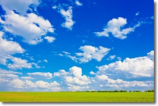
Weather Topic: What are Cumulus Clouds?
Home - Education - Cloud Types - Cumulus Clouds
 Next Topic: Drizzle
Cumulus clouds are fluffy and textured with rounded tops, and
may have flat bottoms. The border of a cumulus cloud
is clearly defined, and can have the appearance of cotton or cauliflower.
Cumulus clouds form at low altitudes (rarely above 2 km) but can grow very tall,
becoming cumulus congestus and possibly the even taller cumulonimbus clouds.
When cumulus clouds become taller, they have a greater chance of producing precipitation.
Next Topic: Drizzle
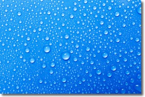
Weather Topic: What is Evaporation?
Home - Education - Precipitation - Evaporation
 Next Topic: Fog
Evaporation is the process which returns water from the earth
back to the atmosphere, and is another crucial process in the water cycle.
Evaporation is the transformation of liquid into gas, and it happens because
molecules are excited by the application of energy and turn into vapor.
In order for water to evaporate it has to be on the surface of a body of water.
Next Topic: Fog
Current conditions powered by WeatherAPI.com


