Weather Alert in New York
Winter Weather Advisory issued February 5 at 12:44PM EST until February 8 at 7:00AM EST by NWS Buffalo NY
AREAS AFFECTED: Monroe; Wayne; Northern Cayuga; Oswego; Livingston; Ontario
DESCRIPTION: * WHAT...A combination of widespread snow and localized lake effect snow expected. Total snow accumulations 3 to 6 inches expected in most areas, with 4 to 7 inches expected along the Lake Ontario shoreline. Winds gusting as high as 35 mph will create areas of blowing and drifting snow. * WHERE...Monroe, Wayne, Northern Cayuga, Oswego, Livingston, and Ontario Counties. * WHEN...From 1 PM Friday to 7 AM EST Sunday. * IMPACTS...Travel will be difficult. The hazardous conditions may impact the Friday evening commute. * ADDITIONAL DETAILS...An Arctic front will bring widespread snow showers to the region Friday morning, which will then taper off to more localized lake effect snow Friday night through Saturday. Winds strengthening behind this front late Friday evening through Saturday will resulting of blowing and drifting of the fresh snowpack.
INSTRUCTION: Periods of snow will result in snow covered roads and limited visibilities. Slow down and use caution while driving. Submit snow reports through our website or social media. During lake effect snow, the weather can vary from bands of locally heavy snow with greatly reduced visibilities to dry conditions just a few miles away. Be prepared for rapid changes in weather, visibility, and road conditions.
Want more detail? Get the Complete 7 Day and Night Detailed Forecast!
Current U.S. National Radar--Current
The Current National Weather Radar is shown below with a UTC Time (subtract 5 hours from UTC to get Eastern Time).

National Weather Forecast--Current
The Current National Weather Forecast and National Weather Map are shown below.

National Weather Forecast for Tomorrow
Tomorrow National Weather Forecast and Tomorrow National Weather Map are show below.

North America Water Vapor (Moisture)
This map shows recent moisture content over North America. Bright and colored areas show high moisture (ie, clouds); brown indicates very little moisture present; black indicates no moisture.

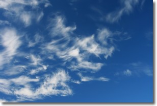
Weather Topic: What are Cirrostratus Clouds?
Home - Education - Cloud Types - Cirrostratus Clouds
 Next Topic: Cirrus Clouds
Cirrostratus clouds are high, thin clouds that form above
20,000 feet and are made mostly of ice crystals. They sometimes look like giant
feathers, horse tails, or curls of hair in the sky.
These clouds are pushed by the jet stream and can move at high speeds reaching
100 mph.
What do they indicate?
They indicate that a precipitation is likely within 24 hours.
Next Topic: Cirrus Clouds
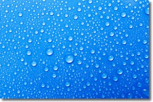
Weather Topic: What is Condensation?
Home - Education - Precipitation - Condensation
 Next Topic: Contrails
Condensation is the process which creates clouds, and therefore
it is a crucial process in the water cycle.
Condensation is the change of matter from a state of gas into a state of liquid,
and it happens because water molecules release heat into the atmosphere and
become organized into a more closely packed structure, what we might see as
water droplets.
Water is always present in the air around us as a vapor, but it's too small for
us to see. When water undergoes the process of condensation it becomes organized
into visible water droplets. You've probably seen condensation happen before on the
surface of a cold drink!
Next Topic: Contrails
Current conditions powered by WeatherAPI.com


