Weather Alert in Idaho
Hydrologic Outlook issued August 24 at 1:57PM MDT by NWS Boise ID
AREAS AFFECTED: Ada, ID; Adams, ID; Boise, ID; Camas, ID; Canyon, ID; Elmore, ID; Gem, ID; Gooding, ID; Jerome, ID; Owyhee, ID; Payette, ID; Twin Falls, ID; Valley, ID; Washington, ID; Baker, OR; Harney, OR; Malheur, OR
DESCRIPTION: ESFBOI A push of monsoonal moisture will bring several days of showers and thunderstorms to the region. Abnormally high moisture will allow for widespread heavy rain accumulation, leading to an increased threat of flash flooding. Tuesday and Wednesday currently look to have the best chance for heavy rain, especially in southeast Oregon, near the ID-NV border, and high terrain in southwest Idaho. Conditions will likely dry out considerably by the end of the week. Burn scars and steep and rocky terrain are at the most risk for flash flooding. The Wapiti Fire burn scar near Grandjean, ID, the Durkee Fire burn scar near Ironside, OR, and the Lava Fire burn scar near Cascade, ID are of particular concern for flash flooding. Recent fires also are vulnerable to flash flooding impacts. Please be aware of impacts in these areas and have multiple ways to receive flash flood warnings. Consider alternate plans if recreating near these areas.
INSTRUCTION: N/A
Want more detail? Get the Complete 7 Day and Night Detailed Forecast!
Current U.S. National Radar--Current
The Current National Weather Radar is shown below with a UTC Time (subtract 5 hours from UTC to get Eastern Time).

National Weather Forecast--Current
The Current National Weather Forecast and National Weather Map are shown below.

National Weather Forecast for Tomorrow
Tomorrow National Weather Forecast and Tomorrow National Weather Map are show below.

North America Water Vapor (Moisture)
This map shows recent moisture content over North America. Bright and colored areas show high moisture (ie, clouds); brown indicates very little moisture present; black indicates no moisture.

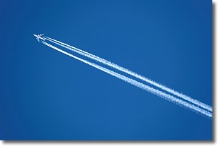
Weather Topic: What are Contrails?
Home - Education - Cloud Types - Contrails
 Next Topic: Cumulonimbus Clouds
A contrail is an artificial cloud, created by the passing of an
aircraft.
Contrails form because water vapor in the exhaust of aircraft engines is suspended
in the air under certain temperatures and humidity conditions. These contrails
are called exhaust contrails.
Another type of contrail can form due to a temporary reduction in air pressure
moving over the plane's surface, causing condensation.
These are called aerodynamic contrails.
When you can see your breath on a cold day, it is also because of condensation.
The reason contrails last longer than the condensation from your breath is
because the water in contrails freezes into ice particles.
Next Topic: Cumulonimbus Clouds
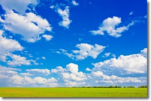
Weather Topic: What are Cumulus Clouds?
Home - Education - Cloud Types - Cumulus Clouds
 Next Topic: Drizzle
Cumulus clouds are fluffy and textured with rounded tops, and
may have flat bottoms. The border of a cumulus cloud
is clearly defined, and can have the appearance of cotton or cauliflower.
Cumulus clouds form at low altitudes (rarely above 2 km) but can grow very tall,
becoming cumulus congestus and possibly the even taller cumulonimbus clouds.
When cumulus clouds become taller, they have a greater chance of producing precipitation.
Next Topic: Drizzle
Current conditions powered by WeatherAPI.com


