Weather Alert in Maryland
Winter Weather Advisory issued March 2 at 2:26AM EST until March 3 at 1:00PM EST by NWS Baltimore MD/Washington DC
AREAS AFFECTED: Washington; Frederick; Extreme Western Allegany; Central and Eastern Allegany; Eastern Garrett; Morgan; Berkeley; Jefferson; Western Mineral; Eastern Mineral
DESCRIPTION: * WHAT...Mixed precipitation expected. Total snow accumulations up to one inch and ice accumulations up to two tenths of an inch. * WHERE...Portions of north central and western Maryland and eastern West Virginia. * WHEN...From 10 PM this evening to 1 PM EST Tuesday. * IMPACTS...Plan on slippery road conditions. The hazardous conditions could impact the Tuesday morning commute. * ADDITIONAL DETAILS...Some locations may see up to an inch of snow between late morning and mid afternoon today, but roadway impacts should be limited. The primary threat to travel will be overnight from a wintry mix, which could briefly be snow or sleet but primarily fall as freezing rain. Precipitation will change to plain rain by midday Tuesday.
INSTRUCTION: Slow down and use caution while traveling. The latest road conditions for the state you are calling from can be obtained by calling 5 1 1.
Want more detail? Get the Complete 7 Day and Night Detailed Forecast!
Current U.S. National Radar--Current
The Current National Weather Radar is shown below with a UTC Time (subtract 5 hours from UTC to get Eastern Time).

National Weather Forecast--Current
The Current National Weather Forecast and National Weather Map are shown below.

National Weather Forecast for Tomorrow
Tomorrow National Weather Forecast and Tomorrow National Weather Map are show below.

North America Water Vapor (Moisture)
This map shows recent moisture content over North America. Bright and colored areas show high moisture (ie, clouds); brown indicates very little moisture present; black indicates no moisture.

Weather Topic: What is Freezing Rain?
Home - Education - Precipitation - Freezing Rain
 Next Topic: Graupel
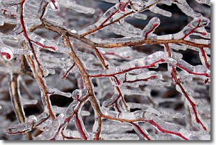
Freezing rain is a condition where precipitation which has fallen in the form of
water droplets reaches temperatures which are below freezing and freezes upon
coming into contact
with surface objects. The result of this precipitation is a glaze of ice which
can be damaging to plants and man-made structures. A severe onset of freezing
rain which results in a very thick glaze of ice is known as an ice storm.
Next Topic: Graupel
Weather Topic: What is Hail?
Home - Education - Precipitation - Hail
 Next Topic: Hole Punch Clouds
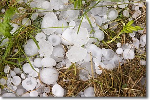
Hail is a form of precipitation which is recognized by large solid balls or
clumps of ice. Hail is created by thunderstorm clouds with strong updrafts of wind.
As the hailstones remain in the updraft, ice is deposited onto them until their
weight becomes heavy enough for them to fall to the earth's surface.
Hail storms can cause significant damage to crops, aircrafts, and man-made structures,
despite the fact that the duration is usually less than ten minutes.
Next Topic: Hole Punch Clouds
Current conditions powered by WeatherAPI.com


