Weather Alert in Iowa
Severe Thunderstorm Warning issued April 2 at 4:12PM CDT until April 2 at 5:15PM CDT by NWS Quad Cities IA IL
AREAS AFFECTED: Henry, IA; Jefferson, IA; Keokuk, IA; Louisa, IA; Washington, IA
DESCRIPTION: SVRDVN The National Weather Service in the Quad Cities has issued a * Severe Thunderstorm Warning for... Northern Henry County in southeastern Iowa... Western Louisa County in southeastern Iowa... Southeastern Keokuk County in southeastern Iowa... Southern Washington County in southeastern Iowa... Jefferson County in southeastern Iowa... * Until 515 PM CDT. * At 412 PM CDT, a severe thunderstorm was located over Packwood, or 8 miles northwest of Fairfield, moving northeast at 55 mph. HAZARD...60 mph wind gusts. SOURCE...Radar indicated. IMPACT...Expect damage to roofs, siding, and trees. * This severe thunderstorm will be near... Fairfield, Richland, Maharishi Vedic City, Packwood, Pleasant Plain, Ollie, Fairfield Municipal Airport, Jefferson County Fairgrounds, Perlee, and East Pleasant Plain around 415 PM CDT. Brighton around 420 PM CDT. Coppock, Germanville, and Washington County Fairgrounds around 425 PM CDT. Washington, Wayland, Washington Airport, and Noble around 430 PM CDT. Other locations in the path of this severe thunderstorm include Ainsworth, Crawfordsville, Marr Park, Cotter, Haskins, Columbus Junction, Columbus City, Wyman, Louisa County Fairgrounds, Gladwin and Fredonia.
INSTRUCTION: Remain alert for a possible tornado! Tornadoes can develop quickly from severe thunderstorms. If you spot a tornado go at once into the basement or small central room in a sturdy structure. For your protection move to an interior room on the lowest floor of a sturdy building. To report severe weather, contact your nearest law enforcement agency. They will send your report to the National Weather Service office in the Quad Cities. A Tornado Watch remains in effect until 800 PM CDT for southeastern and east central Iowa.
Want more detail? Get the Complete 7 Day and Night Detailed Forecast!
Current U.S. National Radar--Current
The Current National Weather Radar is shown below with a UTC Time (subtract 5 hours from UTC to get Eastern Time).

National Weather Forecast--Current
The Current National Weather Forecast and National Weather Map are shown below.

National Weather Forecast for Tomorrow
Tomorrow National Weather Forecast and Tomorrow National Weather Map are show below.

North America Water Vapor (Moisture)
This map shows recent moisture content over North America. Bright and colored areas show high moisture (ie, clouds); brown indicates very little moisture present; black indicates no moisture.

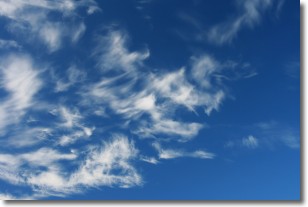
Weather Topic: What are Cirrostratus Clouds?
Home - Education - Cloud Types - Cirrostratus Clouds
 Next Topic: Cirrus Clouds
Cirrostratus clouds are high, thin clouds that form above
20,000 feet and are made mostly of ice crystals. They sometimes look like giant
feathers, horse tails, or curls of hair in the sky.
These clouds are pushed by the jet stream and can move at high speeds reaching
100 mph.
What do they indicate?
They indicate that a precipitation is likely within 24 hours.
Next Topic: Cirrus Clouds
Weather Topic: What is Condensation?
Home - Education - Precipitation - Condensation
 Next Topic: Contrails
Condensation is the process which creates clouds, and therefore
it is a crucial process in the water cycle.
Condensation is the change of matter from a state of gas into a state of liquid,
and it happens because water molecules release heat into the atmosphere and
become organized into a more closely packed structure, what we might see as
water droplets.
Water is always present in the air around us as a vapor, but it's too small for
us to see. When water undergoes the process of condensation it becomes organized
into visible water droplets. You've probably seen condensation happen before on the
surface of a cold drink!
Next Topic: Contrails
Current conditions powered by WeatherAPI.com


