Weather Alert in South Carolina
Flood Warning issued August 15 at 3:12AM EDT until August 19 at 2:00AM EDT by NWS Columbia SC
AREAS AFFECTED: Calhoun, SC; Richland, SC
DESCRIPTION: ...The Flood Warning continues for the following rivers in South Carolina... Congaree River At Congaree River at Congaree NP Near Gadsden affecting Calhoun and Richland Counties. Congaree River At Carolina Eastman affecting Calhoun, Lexington and Richland Counties. * WHAT...Minor flooding is occurring and minor flooding is forecast. * WHERE...Congaree River at Congaree River at Congaree NP Near Gadsden. * WHEN...Until early Tuesday morning. * IMPACTS...At 15.0 feet, Flooding begins in the Congaree National Park. This will begin to produce flooding of portions of the lower boardwalk. At 17.0 feet, The access road to the Sandy Run subdivision becomes flooded. The lower boardwalk in the Congaree National Park becomes flooded by Cedar Creek. At 18.0 feet, Several homes in the Sandy Run subdivision along the river become flooded. At 18 feet the river covers the Weston Lake overlook in the Congaree National Park. Between 18 and 18.5 feet the river begins to cover sections of the elevated boardwalk. * ADDITIONAL DETAILS... - At 2:00 AM EDT Friday the stage was 17.0 feet. - Bankfull stage is 14.0 feet. - Recent Activity...The maximum river stage in the 24 hours ending at 2:00 AM EDT Friday was 17.2 feet. - Forecast...The river is expected to fall below flood stage early Monday morning and continue falling to 11.4 feet Tuesday evening. - Flood stage is 15.0 feet. - http://www.weather.gov/safety/flood
INSTRUCTION: Caution is urged when walking near riverbanks. Residents and those with interests near the river should monitor rising water levels and take action if necessary. Additional information is available at www.weather.gov. The next statement will be issued this afternoon at 315 PM EDT.
Want more detail? Get the Complete 7 Day and Night Detailed Forecast!
Current U.S. National Radar--Current
The Current National Weather Radar is shown below with a UTC Time (subtract 5 hours from UTC to get Eastern Time).

National Weather Forecast--Current
The Current National Weather Forecast and National Weather Map are shown below.

National Weather Forecast for Tomorrow
Tomorrow National Weather Forecast and Tomorrow National Weather Map are show below.

North America Water Vapor (Moisture)
This map shows recent moisture content over North America. Bright and colored areas show high moisture (ie, clouds); brown indicates very little moisture present; black indicates no moisture.

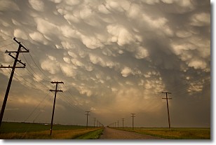
Weather Topic: What are Mammatus Clouds?
Home - Education - Cloud Types - Mammatus Clouds
 Next Topic: Nimbostratus Clouds
A mammatus cloud is a cloud with a unique feature which resembles
a web of pouches hanging along the base of the cloud.
In the United States, mammatus clouds tend to form in the warmer months, commonly
in the Midwest and eastern regions.
While they usually form at the bottom of a cumulonimbis cloud, they can also form
under altostratus, altocumulus, stratocumulus, and cirrus clouds. Mammatus clouds
warn that severe weather is close.
Next Topic: Nimbostratus Clouds
Weather Topic: What is Precipitation?
Home - Education - Precipitation - Precipitation
 Next Topic: Rain
Precipitation can refer to many different forms of water that
may fall from clouds. Precipitation occurs after a cloud has become saturated to
the point where its water particles are more dense than the air below the cloud.
In most cases, precipitation will reach the ground, but it is not uncommon for
precipitation to evaporate before it reaches the earth's surface.
When precipitation evaporates before it contacts the ground it is called Virga.
Graupel, hail, sleet, rain, drizzle, and snow are forms of precipitation, but fog
and mist are not considered precipitation because the water vapor which
constitutes them isn't dense enough to fall to the ground.
Next Topic: Rain
Current conditions powered by WeatherAPI.com


