Weather Alert in Alabama
Flood Watch issued August 3 at 12:39PM EDT until August 4 at 8:00PM EDT by NWS Tallahassee FL
AREAS AFFECTED: Coffee; Dale; Henry; Geneva; Houston; North Walton; Central Walton; Holmes; Washington; Jackson; Inland Bay; Calhoun; Inland Gulf; Inland Franklin; Gadsden; Leon; Inland Jefferson; Madison; Inland Wakulla; South Walton; Coastal Bay; Coastal Gulf; Coastal Franklin; Coastal Jefferson; Coastal Wakulla; Northern Liberty; Southern Liberty; Quitman; Clay; Randolph; Calhoun; Terrell; Dougherty; Lee; Worth; Turner; Tift; Ben Hill; Irwin; Early; Miller; Baker; Mitchell; Colquitt; Cook; Berrien; Seminole; Decatur; Grady; Thomas; Brooks; Lowndes; Lanier
DESCRIPTION: * WHAT...Flooding caused by excessive rainfall continues to be possible. * WHERE...Portions of southeast Alabama, including the following areas, Coffee, Dale, Geneva, Henry and Houston, Florida, including the following areas, Calhoun, Central Walton, Coastal Bay, Coastal Franklin, Coastal Gulf, Coastal Jefferson, Coastal Wakulla, Gadsden, Holmes, Inland Bay, Inland Franklin, Inland Gulf, Inland Jefferson, Inland Wakulla, Jackson, Leon, Madison, North Walton, Northern Liberty, South Walton, Southern Liberty and Washington, and Georgia, including the following areas, Baker, Ben Hill, Berrien, Brooks, Calhoun, Clay, Colquitt, Cook, Decatur, Dougherty, Early, Grady, Irwin, Lanier, Lee, Lowndes, Miller, Mitchell, Quitman, Randolph, Seminole, Terrell, Thomas, Tift, Turner and Worth. * WHEN...Through Monday evening. * IMPACTS...Excessive runoff may result in flooding of rivers, creeks, streams, and other low-lying and flood-prone locations. Flooding may occur in poor drainage and urban areas. Storm drains and ditches may become clogged with debris. * ADDITIONAL DETAILS... - Heavy rain threat remains likely through Monday afternoon. The heaviest rains should slowly shift north from the Panhandle and into Alabama and Georgia this afternoon and evening. Another round of showers and storms is expected to develop along the coast late tonight and into Monday morning past sunrise. For Monday, the flood threat will slowly shift west and the highest probabilities for localized flooding rain will be across the Panhandle, extreme southwest Georgia, and into Alabama. Additional widespread rainfall this afternoon and into Monday will be around 3 to 4 inches, but localized areas could see 4 to 8 inches in any slow moving storms given likely rainfall rates of 2 to 4 inches per hour. - http://www.weather.gov/safety/flood
INSTRUCTION: You should monitor later forecasts and be alert for possible Flood Warnings. Those living in areas prone to flooding should be prepared to take action should flooding develop.
Want more detail? Get the Complete 7 Day and Night Detailed Forecast!
Current U.S. National Radar--Current
The Current National Weather Radar is shown below with a UTC Time (subtract 5 hours from UTC to get Eastern Time).

National Weather Forecast--Current
The Current National Weather Forecast and National Weather Map are shown below.

National Weather Forecast for Tomorrow
Tomorrow National Weather Forecast and Tomorrow National Weather Map are show below.

North America Water Vapor (Moisture)
This map shows recent moisture content over North America. Bright and colored areas show high moisture (ie, clouds); brown indicates very little moisture present; black indicates no moisture.

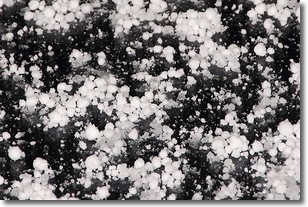
Weather Topic: What is Graupel?
Home - Education - Precipitation - Graupel
 Next Topic: Hail
Graupel is a form of precipitation that is created by atmospheric conditions
which cause supercooled water droplets to contact snow crystals and freeze to
their surface.
Sometimes known as soft hail or snow pellets, graupel is delicate and easily
destroyed by touch. Whereas hail usually falls during severe weather, graupel
doesn't require such conditions to form, and can form in mild precipitation
similar to situations which produce snowfall.
Next Topic: Hail
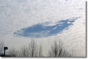
Weather Topic: What are Hole Punch Clouds?
Home - Education - Cloud Types - Hole Punch Clouds
 Next Topic: Mammatus Clouds
A hole punch cloud is an unusual occurrence when a disk-shaped
hole appears in a cirrostratus, cirrocumulus, or altocumulus cloud.
When part of the cloud forms ice crystals, water droplets in the surrounding area
of the cloud evaporate. The effect of this process produces a large elliptical
gap in the cloud. The hole punch cloud formation is rare, but it is not specific
to any geographic area.
Other names which have been used to describe this phenomena include fallstreak hole,
skypunch, and cloud hole.
Next Topic: Mammatus Clouds
Current conditions powered by WeatherAPI.com


