Weather Alert in North Carolina
Flood Warning issued May 18 at 10:35AM EDT until May 22 at 2:00AM EDT by NWS Wilmington NC
AREAS AFFECTED: Robeson, NC
DESCRIPTION: ...The National Weather Service in Wilmington NC has issued a Flood Warning for the following rivers in North Carolina... Lumber River Near Lumberton affecting Robeson County. * WHAT...Minor flooding is forecast. * WHERE...Lumber River near Lumberton. * WHEN...From late tonight to early Thursday morning. * IMPACTS...At 13.0 feet, Low land flooding will occur along the river. The flood waters may affect some residential property as water backs up into the drainage ditches in the city. * ADDITIONAL DETAILS... - At 10:20 AM EDT Sunday the stage was 12.5 feet. - Forecast...The river is expected to rise above flood stage just after midnight tonight to a crest of 13.2 feet early tomorrow afternoon. It will then fall below flood stage Wednesday morning. - Flood stage is 13.0 feet. - weather.gov/safety/flood
INSTRUCTION: Turn around, don't drown when encountering flooded roads. Most flood deaths occur in vehicles. Additional information is available at water.noaa.gov/wfo/ilm . The next statement will be issued by late tonight.
Want more detail? Get the Complete 7 Day and Night Detailed Forecast!
Current U.S. National Radar--Current
The Current National Weather Radar is shown below with a UTC Time (subtract 5 hours from UTC to get Eastern Time).

National Weather Forecast--Current
The Current National Weather Forecast and National Weather Map are shown below.

National Weather Forecast for Tomorrow
Tomorrow National Weather Forecast and Tomorrow National Weather Map are show below.

North America Water Vapor (Moisture)
This map shows recent moisture content over North America. Bright and colored areas show high moisture (ie, clouds); brown indicates very little moisture present; black indicates no moisture.

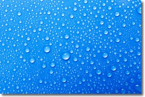
Weather Topic: What is Condensation?
Home - Education - Precipitation - Condensation
 Next Topic: Contrails
Condensation is the process which creates clouds, and therefore
it is a crucial process in the water cycle.
Condensation is the change of matter from a state of gas into a state of liquid,
and it happens because water molecules release heat into the atmosphere and
become organized into a more closely packed structure, what we might see as
water droplets.
Water is always present in the air around us as a vapor, but it's too small for
us to see. When water undergoes the process of condensation it becomes organized
into visible water droplets. You've probably seen condensation happen before on the
surface of a cold drink!
Next Topic: Contrails
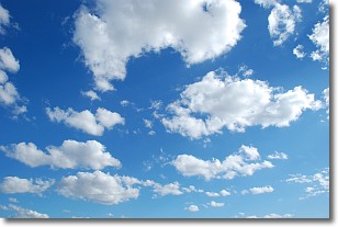
Weather Topic: What are Cumulonimbus Clouds?
Home - Education - Cloud Types - Cumulonimbus Clouds
 Next Topic: Cumulus Clouds
The final form taken by a growing cumulus cloud is the
cumulonimbus cloud, which is very tall and dense.
The tower of a cumulonimbus cloud can soar 23 km into the atmosphere, although
most commonly they stop growing at an altitude of 6 km.
Even small cumulonimbus clouds appear very large in comparison to other cloud types.
They can signal the approach of stormy weather, such as thunderstorms or blizzards.
Next Topic: Cumulus Clouds
Current conditions powered by WeatherAPI.com


