Weather Alert in Texas
Wind Advisory issued February 24 at 12:22AM CST until February 24 at 6:00PM CST by NWS Fort Worth TX
AREAS AFFECTED: Grayson; Fannin; Lamar; Denton; Collin; Hunt; Delta; Hopkins; Parker; Tarrant; Dallas; Rockwall; Kaufman; Van Zandt; Rains; Hood; Somervell; Johnson; Ellis; Henderson; Hamilton; Bosque; Hill; Navarro; Coryell; Bell; McLennan
DESCRIPTION: * WHAT...South winds 20 to 25 mph with gusts up to 35 mph expected. * WHERE...Portions of north central and northeast Texas. * WHEN...From noon today to 6 PM CST this evening. * IMPACTS...Unsecured outdoor items may be blown around in the wind. Driving on area roadways may become difficult, especially for high-profile vehicles. Small tree limbs could break and cause damage.
INSTRUCTION: A Wind Advisory means that sustained winds of at least 20 to 30 mph are expected. Winds this strong can make driving difficult, especially for high profile vehicles. Boaters should use extra caution when venturing onto area lakes. Residents may wish to take action to secure trash cans, lawn furniture, and other lightweight outdoor objects that may be blown around in the strong winds.
Want more detail? Get the Complete 7 Day and Night Detailed Forecast!
Current U.S. National Radar--Current
The Current National Weather Radar is shown below with a UTC Time (subtract 5 hours from UTC to get Eastern Time).

National Weather Forecast--Current
The Current National Weather Forecast and National Weather Map are shown below.

National Weather Forecast for Tomorrow
Tomorrow National Weather Forecast and Tomorrow National Weather Map are show below.

North America Water Vapor (Moisture)
This map shows recent moisture content over North America. Bright and colored areas show high moisture (ie, clouds); brown indicates very little moisture present; black indicates no moisture.

Weather Topic: What are Cumulus Clouds?
Home - Education - Cloud Types - Cumulus Clouds
 Next Topic: Drizzle
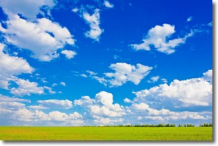
Cumulus clouds are fluffy and textured with rounded tops, and
may have flat bottoms. The border of a cumulus cloud
is clearly defined, and can have the appearance of cotton or cauliflower.
Cumulus clouds form at low altitudes (rarely above 2 km) but can grow very tall,
becoming cumulus congestus and possibly the even taller cumulonimbus clouds.
When cumulus clouds become taller, they have a greater chance of producing precipitation.
Next Topic: Drizzle
Weather Topic: What is Evaporation?
Home - Education - Precipitation - Evaporation
 Next Topic: Fog
Evaporation is the process which returns water from the earth
back to the atmosphere, and is another crucial process in the water cycle.
Evaporation is the transformation of liquid into gas, and it happens because
molecules are excited by the application of energy and turn into vapor.
In order for water to evaporate it has to be on the surface of a body of water.
Next Topic: Fog
Current conditions powered by WeatherAPI.com


