Weather Alert in Texas
Wind Advisory issued February 24 at 12:22AM CST until February 24 at 6:00PM CST by NWS Fort Worth TX
AREAS AFFECTED: Grayson; Fannin; Lamar; Denton; Collin; Hunt; Delta; Hopkins; Parker; Tarrant; Dallas; Rockwall; Kaufman; Van Zandt; Rains; Hood; Somervell; Johnson; Ellis; Henderson; Hamilton; Bosque; Hill; Navarro; Coryell; Bell; McLennan
DESCRIPTION: * WHAT...South winds 20 to 25 mph with gusts up to 35 mph expected. * WHERE...Portions of north central and northeast Texas. * WHEN...From noon today to 6 PM CST this evening. * IMPACTS...Unsecured outdoor items may be blown around in the wind. Driving on area roadways may become difficult, especially for high-profile vehicles. Small tree limbs could break and cause damage.
INSTRUCTION: A Wind Advisory means that sustained winds of at least 20 to 30 mph are expected. Winds this strong can make driving difficult, especially for high profile vehicles. Boaters should use extra caution when venturing onto area lakes. Residents may wish to take action to secure trash cans, lawn furniture, and other lightweight outdoor objects that may be blown around in the strong winds.
Want more detail? Get the Complete 7 Day and Night Detailed Forecast!
Current U.S. National Radar--Current
The Current National Weather Radar is shown below with a UTC Time (subtract 5 hours from UTC to get Eastern Time).

National Weather Forecast--Current
The Current National Weather Forecast and National Weather Map are shown below.

National Weather Forecast for Tomorrow
Tomorrow National Weather Forecast and Tomorrow National Weather Map are show below.

North America Water Vapor (Moisture)
This map shows recent moisture content over North America. Bright and colored areas show high moisture (ie, clouds); brown indicates very little moisture present; black indicates no moisture.

Weather Topic: What are Cumulonimbus Clouds?
Home - Education - Cloud Types - Cumulonimbus Clouds
 Next Topic: Cumulus Clouds
The final form taken by a growing cumulus cloud is the
cumulonimbus cloud, which is very tall and dense.
The tower of a cumulonimbus cloud can soar 23 km into the atmosphere, although
most commonly they stop growing at an altitude of 6 km.
Even small cumulonimbus clouds appear very large in comparison to other cloud types.
They can signal the approach of stormy weather, such as thunderstorms or blizzards.
Next Topic: Cumulus Clouds
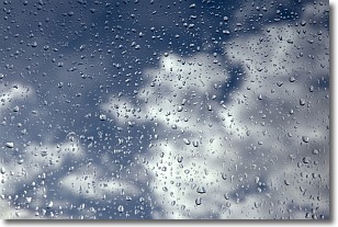
Weather Topic: What is Drizzle?
Home - Education - Precipitation - Drizzle
 Next Topic: Evaporation
Drizzle is precipitation in the form of water droplets which are
smaller than raindrops.
Drizzle is characterized by fine, gently falling droplets and typically does not
impact human habitation in a negative way. The exception to this is freezing drizzle,
a condition where drizzle freezes immediately upon reaching earth's surface.
Freezing drizzle is still less dangerous than freezing rain, but can
potentially result in hazardous road conditions.
Next Topic: Evaporation
Current conditions powered by WeatherAPI.com


