Weather Alert in Washington
Fire Weather Watch issued August 22 at 2:08PM PDT until August 26 at 9:00PM PDT by NWS Spokane WA
AREAS AFFECTED: East Washington Central Cascades; East Portion of North Cascades National Park / Lake Chelan National Recreation Area; East Washington North Cascades; Methow Valley
DESCRIPTION: ...HOT, DRY, AND UNSTABLE CONDITIONS FOR MONDAY AND TUESDAY... .A strong ridge of high pressure will bring a period of hot and dry conditions to the central and northern Cascades of Washington this weekend. The ridge will shift east of the Cascades early next week with the atmosphere becoming more unstable at that time. Increased instability with hot and dry conditions will bring the potential for critical fire weather conditions. The National Weather Service in Spokane has issued a Fire Weather Watch for hot, dry, and unstable conditions, which is in effect from Monday afternoon through Tuesday evening. * Affected Area: East Washington Central Cascades (Zone 696), East Portion of North Cascades National Park/Lake Chelan National Recreation Area (Zone 697), East Washington North Cascades (Zone 698) and Methow Valley (Zone 704). * Winds: East-Southeast 3 to 7 mph in the afternoon switching West 5 to 10 mph in the evening. * Timing: Afternoon and evening for both Monday and Tuesday. * Relative Humidities: Below 4,000 feet: 13 to 20 percent. Above 4,000 feet: 20 to 30 percent. * Temperatures: Below 4,000 feet: 90 to 102 degrees. Above 4,000 feet: 75 to 90 degrees. * Impacts: Hot, dry, and unstable conditions may lead to rapid fire growth on any new or existing fires.
INSTRUCTION: A Fire Weather Watch means that critical fire weather conditions are forecast to occur. Listen for later forecasts and possible Red Flag Warnings.
Want more detail? Get the Complete 7 Day and Night Detailed Forecast!
Current U.S. National Radar--Current
The Current National Weather Radar is shown below with a UTC Time (subtract 5 hours from UTC to get Eastern Time).

National Weather Forecast--Current
The Current National Weather Forecast and National Weather Map are shown below.

National Weather Forecast for Tomorrow
Tomorrow National Weather Forecast and Tomorrow National Weather Map are show below.

North America Water Vapor (Moisture)
This map shows recent moisture content over North America. Bright and colored areas show high moisture (ie, clouds); brown indicates very little moisture present; black indicates no moisture.

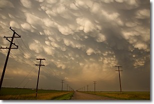
Weather Topic: What are Mammatus Clouds?
Home - Education - Cloud Types - Mammatus Clouds
 Next Topic: Nimbostratus Clouds
A mammatus cloud is a cloud with a unique feature which resembles
a web of pouches hanging along the base of the cloud.
In the United States, mammatus clouds tend to form in the warmer months, commonly
in the Midwest and eastern regions.
While they usually form at the bottom of a cumulonimbis cloud, they can also form
under altostratus, altocumulus, stratocumulus, and cirrus clouds. Mammatus clouds
warn that severe weather is close.
Next Topic: Nimbostratus Clouds
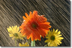
Weather Topic: What is Precipitation?
Home - Education - Precipitation - Precipitation
 Next Topic: Rain
Precipitation can refer to many different forms of water that
may fall from clouds. Precipitation occurs after a cloud has become saturated to
the point where its water particles are more dense than the air below the cloud.
In most cases, precipitation will reach the ground, but it is not uncommon for
precipitation to evaporate before it reaches the earth's surface.
When precipitation evaporates before it contacts the ground it is called Virga.
Graupel, hail, sleet, rain, drizzle, and snow are forms of precipitation, but fog
and mist are not considered precipitation because the water vapor which
constitutes them isn't dense enough to fall to the ground.
Next Topic: Rain
Current conditions powered by WeatherAPI.com


