Weather Alert in Colorado
Fire Weather Watch issued February 24 at 12:18PM MST until February 25 at 7:00PM MST by NWS Goodland KS
AREAS AFFECTED: Kit Carson County; Cheyenne; Dundy
DESCRIPTION: ...Strong Winds Expected Wednesday... .Strong westerly winds will spread over the plains of Colorado and adjacent areas Wednesday afternoon. Strong winds, combined with very dry fuels will promote explosive fire growth. A strong cold front is expected to sweep across the area around sunset, shifting winds to the north-northeast making any ongoing fire control efforts difficult. The National Weather Service in Goodland has issued a Fire Weather Watch for wind and low relative humidity, which is in effect from Wednesday morning through Wednesday evening. * AFFECTED AREA...Fire Weather Zones 001 Cheyenne KS, 079 Dundy and 253 Kit Carson. * TIMING...From Wednesday morning through Wednesday evening. * WINDS...Northwest 15 to 25 mph with gusts up to 45 mph. * RELATIVE HUMIDITY...As low as 15 percent. * IMPACTS...Unpredictable fire behavior. Any fires that develop may rapidly grow and spread out of control.
INSTRUCTION: A Fire Weather Watch means that critical fire weather conditions are forecast to occur. Listen for later forecasts and possible red flag warnings.
Want more detail? Get the Complete 7 Day and Night Detailed Forecast!
Current U.S. National Radar--Current
The Current National Weather Radar is shown below with a UTC Time (subtract 5 hours from UTC to get Eastern Time).

National Weather Forecast--Current
The Current National Weather Forecast and National Weather Map are shown below.

National Weather Forecast for Tomorrow
Tomorrow National Weather Forecast and Tomorrow National Weather Map are show below.

North America Water Vapor (Moisture)
This map shows recent moisture content over North America. Bright and colored areas show high moisture (ie, clouds); brown indicates very little moisture present; black indicates no moisture.

Weather Topic: What are Altostratus Clouds?
Home - Education - Cloud Types - Altostratus Clouds
 Next Topic: Cirrocumulus Clouds
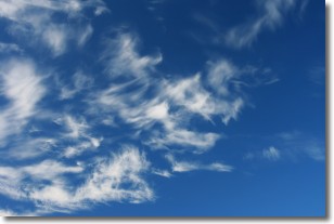
Altostratus clouds form at mid to high-level altitudes
(between 2 and 7 km) and are created by a warm, stable air mass which causes
water vapor
to condense as it rise through the atmosphere. Usually altostratus clouds are
featureless sheets characterized by a uniform color.
In some cases, wind punching through the cloud formation may give it a waved
appearance, called altostratus undulatus. Altostratus clouds
are commonly seen with other cloud formations accompanying them.
Next Topic: Cirrocumulus Clouds
Weather Topic: What are Cirrostratus Clouds?
Home - Education - Cloud Types - Cirrostratus Clouds
 Next Topic: Cirrus Clouds
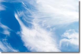
Cirrostratus clouds are high, thin clouds that form above
20,000 feet and are made mostly of ice crystals. They sometimes look like giant
feathers, horse tails, or curls of hair in the sky.
These clouds are pushed by the jet stream and can move at high speeds reaching
100 mph.
What do they indicate?
They indicate that a precipitation is likely within 24 hours.
Next Topic: Cirrus Clouds
Current conditions powered by WeatherAPI.com


