Weather Alert in Iowa
Flood Watch issued June 25 at 8:57PM CDT until June 30 at 1:00AM CDT by NWS La Crosse WI
AREAS AFFECTED: Floyd
DESCRIPTION: ...The National Weather Service in La Crosse WI has issued a Flood Watch for the following rivers in Iowa... Turkey River at Spillville affecting Winneshiek County. ...The Flood Watch continues for the following rivers in Wisconsin... Minnesota...Iowa... Black River at Black River Falls affecting Jackson County. Black River Near Galesville affecting La Crosse and Trempealeau zones. Turtle Creek Near Austin 3NW affecting Mower County. Kickapoo River at Viola affecting Richland and Vernon Counties. Kickapoo River at Readstown affecting Vernon County. Kickapoo River at Soldiers Grove affecting Crawford County. Kickapoo River at Gays Mills affecting Crawford County. Yellow River at Necedah affecting Juneau County. Cedar River at Charles City affecting Floyd County. * WHAT...Flooding is possible. * WHERE...Cedar River at Charles City. * WHEN...From Friday morning to early Monday morning. * IMPACTS...At 15.0 feet, Leland Avenue and Park Drive at 19th Avenue begins to flood. * ADDITIONAL DETAILS... - At 8:30 PM CDT Wednesday the stage was 4.7 feet. - Forecast...Flood stage may be reached late Friday morning. - Flood stage is 12.0 feet. - http://www.weather.gov/safety/flood
INSTRUCTION: If you are in the watch area, remain alert to possible flooding. Additional river and weather information is available at www.weather.gov/lacrosse. The next statement will be issued Thursday morning by 1100 AM CDT.
Want more detail? Get the Complete 7 Day and Night Detailed Forecast!
Current U.S. National Radar--Current
The Current National Weather Radar is shown below with a UTC Time (subtract 5 hours from UTC to get Eastern Time).

National Weather Forecast--Current
The Current National Weather Forecast and National Weather Map are shown below.

National Weather Forecast for Tomorrow
Tomorrow National Weather Forecast and Tomorrow National Weather Map are show below.

North America Water Vapor (Moisture)
This map shows recent moisture content over North America. Bright and colored areas show high moisture (ie, clouds); brown indicates very little moisture present; black indicates no moisture.

Weather Topic: What are Fractus Clouds?
Home - Education - Cloud Types - Fractus Clouds
 Next Topic: Freezing Rain
A fractus cloud (scud) is a fragmented, tattered cloud which has
likely been sheared off of another cloud. They are accessory clouds, meaning they
develop from parent clouds, and are named in a way which describes the original
cloud which contained them.
Fractus clouds which have originated from cumulus clouds are referred to as
cumulus fractus, while fractus clouds which have originated from stratus clouds
are referred to as stratus fractus. Under certain conditions a fractus cloud might
merge with another cloud, or develop into a cumulus cloud, but usually a
fractus cloud seen by itself will dissipate rapidly.
They are often observed on the leading and trailing edges of storm clouds,
and are a display of wind activity.
Next Topic: Freezing Rain
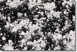
Weather Topic: What is Graupel?
Home - Education - Precipitation - Graupel
 Next Topic: Hail
Graupel is a form of precipitation that is created by atmospheric conditions
which cause supercooled water droplets to contact snow crystals and freeze to
their surface.
Sometimes known as soft hail or snow pellets, graupel is delicate and easily
destroyed by touch. Whereas hail usually falls during severe weather, graupel
doesn't require such conditions to form, and can form in mild precipitation
similar to situations which produce snowfall.
Next Topic: Hail
Current conditions powered by WeatherAPI.com


