Weather Alert in Indiana
Flood Warning issued March 3 at 10:47PM EST until March 4 at 9:18PM EST by NWS Indianapolis IN
AREAS AFFECTED: Bartholomew, IN
DESCRIPTION: ...The Flood Warning continues for the following rivers in Indiana... Haw Creek near Clifford. White River at Elliston. Youngs Creek at Amity. White River at Newberry. ...The Flood Warning is extended for the following rivers in Indiana... East Fork White River at Seymour. .Multiple rounds of rainfall over central Indiana over the next several days are expected to bring at least minor flooding on area rivers and streams. Flooding is expected to develop along portions of the East Fork White and lower White basins over the next 48 hours. Forecast crests issued today include rainfall amounts of 3 to 4 inches over large portions of the East Fork White and lower White basins from this morning through Friday morning, but additional rainfall expected from Friday onward will likely increase crests and lengthen the amount of time in flood. * WHAT...Moderate flooding is forecast. * WHERE...Haw Creek near Clifford. * WHEN...Until late tomorrow evening. * IMPACTS...At 14.5 feet, Near major flooding in progress along Haw Creek. Flooded roads include CR 450 N, Rocky Ford Road, 10th Street and Marr Road according to Columbus Response Plan. * ADDITIONAL DETAILS... - At 10:15 PM EST Tuesday the stage was 7.5 feet. - Forecast...The river is expected to rise above flood stage just after midnight tonight to a crest of 14.5 feet tomorrow morning. It will then fall below flood stage tomorrow afternoon. - Flood stage is 12.0 feet. - http://www.weather.gov/safety/flood
INSTRUCTION: Stay tuned to further developments by listening to your local radio, television, or NOAA Weather Radio for further information. Be especially cautious at night when it is harder to recognize the dangers of flooding. Additional information is available at www.weather.gov/ind. The next statement should be issued Wednesday afternoon by around 100 PM EST.
Want more detail? Get the Complete 7 Day and Night Detailed Forecast!
Current U.S. National Radar--Current
The Current National Weather Radar is shown below with a UTC Time (subtract 5 hours from UTC to get Eastern Time).

National Weather Forecast--Current
The Current National Weather Forecast and National Weather Map are shown below.

National Weather Forecast for Tomorrow
Tomorrow National Weather Forecast and Tomorrow National Weather Map are show below.

North America Water Vapor (Moisture)
This map shows recent moisture content over North America. Bright and colored areas show high moisture (ie, clouds); brown indicates very little moisture present; black indicates no moisture.

Weather Topic: What is Snow?
Home - Education - Precipitation - Snow
 Next Topic: Stratocumulus Clouds
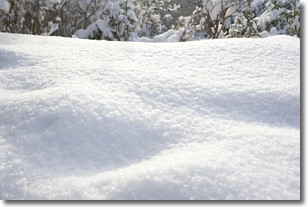
Snow is precipitation taking the form of ice crystals. Each ice crystal, or snowflake,
has unique characteristics, but all of them grow in a hexagonal structure.
Snowfall can last for sustained periods of time and result in significant buildup
of snow on the ground.
On the earth's surface, snow starts out light and powdery, but as it begins to melt
it tends to become more granular, producing small bits of ice which have the consistency of
sand. After several cycles of melting and freezing, snow can become very dense
and ice-like, commonly known as snow pack.
Next Topic: Stratocumulus Clouds
Weather Topic: What are Stratus Clouds?
Home - Education - Cloud Types - Stratus Clouds
 Next Topic: Wall Clouds
Stratus clouds are similar to altostratus clouds, but form at a
lower altitude and are identified by their fog-like appearance, lacking the
distinguishing features of most clouds.
Stratus clouds are wider than most clouds, and their base has a smooth, uniform
look which is lighter in color than a nimbostratus cloud.
The presence of a stratus cloud indicates the possibility of minor precipitation,
such as drizzle, but heavier precipitation does not typically arrive in the form
of a stratus cloud.
Next Topic: Wall Clouds
Current conditions powered by WeatherAPI.com


